You are here: Home > Network List > TA - USArray Transportable Network (new EarthScope stations) Stations List
> Station MSTX Muleshoe, TX, USA > Earthquake Result Viewer
MSTX Muleshoe, TX, USA - Earthquake Result Viewer
| Earthquake location: |
Hokkaido, Japan Region |
| Earthquake latitude/longitude: |
41.9/143.8 |
| Earthquake time(UTC): |
2008/09/11 (255) 00:20:50 GMT |
| Earthquake Depth: |
25 km |
| Earthquake Magnitude: |
6.1 MB, 7.0 MS, 6.8 MW, 6.8 MW |
| Earthquake Catalog/Contributor: |
WHDF/NEIC |
|
| Network: |
TA USArray Transportable Network (new EarthScope stations) |
| Station: |
MSTX Muleshoe, TX, USA |
| Lat/Lon: |
33.97 N/102.77 W |
| Elevation: |
1167 m |
|
| Distance: |
82.9 deg |
| Az: |
50.184 deg |
| Baz: |
316.365 deg |
| Ray Param: |
0.046507623 |
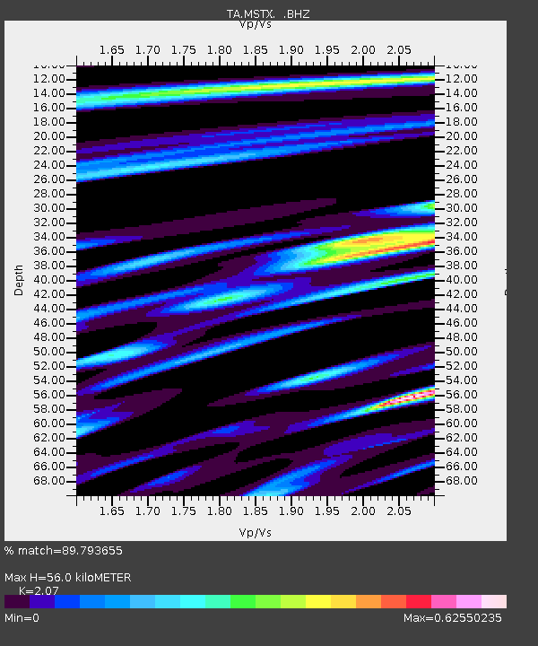
| Estimated Moho Depth: |
56.0 km |
| Estimated Crust Vp/Vs: |
2.07 |
| Assumed Crust Vp: |
6.129 km/s |
| Estimated Crust Vs: |
2.961 km/s |
| Estimated Crust Poisson's Ratio: |
0.35 |
|
| Radial Match: |
89.793655 % |
| Radial Bump: |
400 |
| Transverse Match: |
65.815796 % |
| Transverse Bump: |
400 |
| SOD ConfigId: |
2560 |
| Insert Time: |
2010-03-06 07:45:36.198 +0000 |
| GWidth: |
2.5 |
| Max Bumps: |
400 |
| Tol: |
0.001 |
|
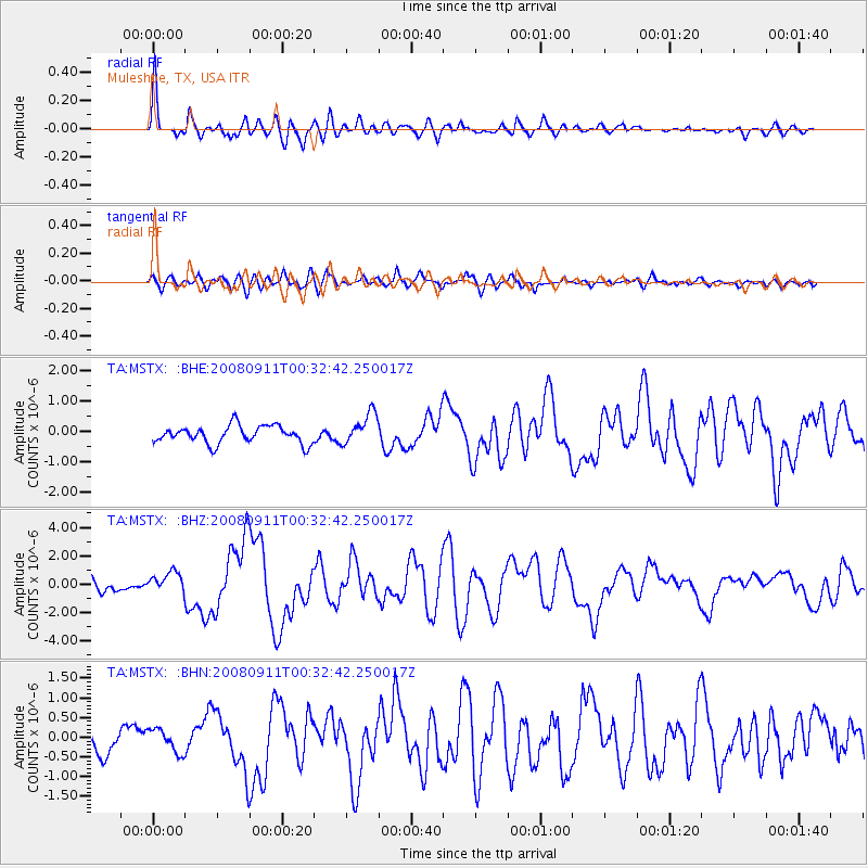
Signal To Noise
| Channel | StoN | STA | LTA |
| TA:MSTX: :BHZ:20080911T00:32:42.250017Z | 1.5937737 | 7.107673E-7 | 4.4596501E-7 |
| TA:MSTX: :BHN:20080911T00:32:42.250017Z | 1.3433706 | 2.962024E-7 | 2.2049196E-7 |
| TA:MSTX: :BHE:20080911T00:32:42.250017Z | 1.7890157 | 5.1520965E-7 | 2.87985E-7 |
| Arrivals |
| Ps | 10.0 SECOND |
| PpPs | 27 SECOND |
| PsPs/PpSs | 37 SECOND |


