You are here: Home > Network List > TA - USArray Transportable Network (new EarthScope stations) Stations List
> Station MSTX Muleshoe, TX, USA > Earthquake Result Viewer
MSTX Muleshoe, TX, USA - Earthquake Result Viewer
| Earthquake location: |
Kermadec Islands Region |
| Earthquake latitude/longitude: |
-27.4/-176.3 |
| Earthquake time(UTC): |
2009/02/18 (049) 21:53:45 GMT |
| Earthquake Depth: |
25 km |
| Earthquake Magnitude: |
6.8 MB, 7.2 MS, 6.9 MW, 6.9 MW |
| Earthquake Catalog/Contributor: |
WHDF/NEIC |
|
| Network: |
TA USArray Transportable Network (new EarthScope stations) |
| Station: |
MSTX Muleshoe, TX, USA |
| Lat/Lon: |
33.97 N/102.77 W |
| Elevation: |
1167 m |
|
| Distance: |
92.6 deg |
| Az: |
52.931 deg |
| Baz: |
238.586 deg |
| Ray Param: |
0.041415606 |
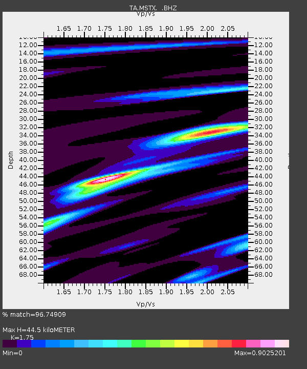
| Estimated Moho Depth: |
44.5 km |
| Estimated Crust Vp/Vs: |
1.75 |
| Assumed Crust Vp: |
6.129 km/s |
| Estimated Crust Vs: |
3.502 km/s |
| Estimated Crust Poisson's Ratio: |
0.26 |
|
| Radial Match: |
96.74909 % |
| Radial Bump: |
289 |
| Transverse Match: |
81.82048 % |
| Transverse Bump: |
400 |
| SOD ConfigId: |
2658 |
| Insert Time: |
2010-03-06 07:45:48.151 +0000 |
| GWidth: |
2.5 |
| Max Bumps: |
400 |
| Tol: |
0.001 |
|

Signal To Noise
| Channel | StoN | STA | LTA |
| TA:MSTX: :BHZ:20090218T22:06:23.050015Z | 11.537806 | 2.6567025E-6 | 2.3026062E-7 |
| TA:MSTX: :BHN:20090218T22:06:23.050015Z | 1.4855403 | 5.0813975E-7 | 3.4205718E-7 |
| TA:MSTX: :BHE:20090218T22:06:23.050015Z | 2.7775178 | 1.093901E-6 | 3.9384125E-7 |
| Arrivals |
| Ps | 5.5 SECOND |
| PpPs | 20 SECOND |
| PsPs/PpSs | 25 SECOND |


