You are here: Home > Network List > CI - Caltech Regional Seismic Network Stations List
> Station DAN Danby, California, USA > Earthquake Result Viewer
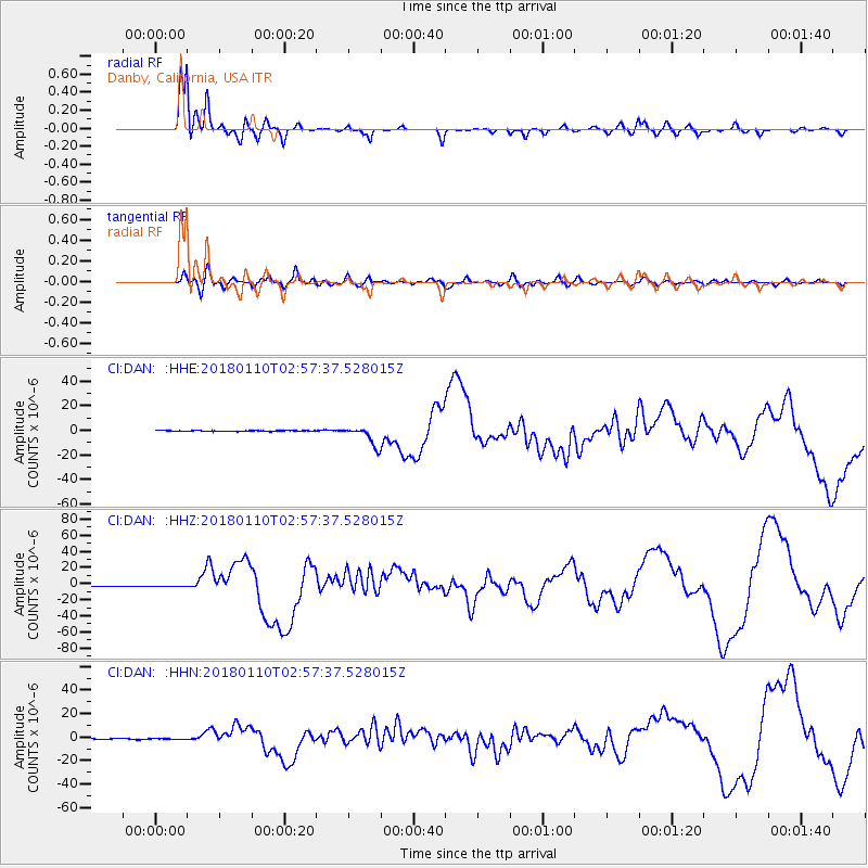
DAN Danby, California, USA - Earthquake Result Viewer
*The percent match for this event was below the threshold and hence no stack was calculated.
| Earthquake location: |
North Of Honduras |
| Earthquake latitude/longitude: |
17.5/-83.6 |
| Earthquake time(UTC): |
2018/01/10 (010) 02:51:31 GMT |
| Earthquake Depth: |
33 km |
| Earthquake Magnitude: |
7.8 Mi |
| Earthquake Catalog/Contributor: |
NEIC PDE/pt |
|
| Network: |
CI Caltech Regional Seismic Network |
| Station: |
DAN Danby, California, USA |
| Lat/Lon: |
34.64 N/115.38 W |
| Elevation: |
398 m |
|
| Distance: |
33.1 deg |
| Az: |
307.24 deg |
| Baz: |
112.874 deg |
| Ray Param: |
$rayparam |
*The percent match for this event was below the threshold and hence was not used in the summary stack. |
|
| Radial Match: |
93.31941 % |
| Radial Bump: |
266 |
| Transverse Match: |
77.932816 % |
| Transverse Bump: |
400 |
| SOD ConfigId: |
13570011 |
| Insert Time: |
2019-04-29 12:57:25.710 +0000 |
| GWidth: |
2.5 |
| Max Bumps: |
400 |
| Tol: |
0.001 |
|
Signal To Noise
| Channel | StoN | STA | LTA |
| CI:DAN: :HHZ:20180110T02:57:37.528015Z | 1.2903371 | 4.6157407E-7 | 3.577159E-7 |
| CI:DAN: :HHN:20180110T02:57:37.528015Z | 0.97273344 | 3.8308056E-7 | 3.9381865E-7 |
| CI:DAN: :HHE:20180110T02:57:37.528015Z | 1.399056 | 4.9710883E-7 | 3.553173E-7 |
| Arrivals |
| Ps | |
| PpPs | |
| PsPs/PpSs | |


