You are here: Home > Network List > TA - USArray Transportable Network (new EarthScope stations) Stations List
> Station MSTX Muleshoe, TX, USA > Earthquake Result Viewer
MSTX Muleshoe, TX, USA - Earthquake Result Viewer
| Earthquake location: |
Samoa Islands Region |
| Earthquake latitude/longitude: |
-15.5/-172.1 |
| Earthquake time(UTC): |
2009/09/29 (272) 17:48:10 GMT |
| Earthquake Depth: |
18 km |
| Earthquake Magnitude: |
7.1 MB, 8.1 MS, 8.1 MW, 8.0 MW |
| Earthquake Catalog/Contributor: |
WHDF/NEIC |
|
| Network: |
TA USArray Transportable Network (new EarthScope stations) |
| Station: |
MSTX Muleshoe, TX, USA |
| Lat/Lon: |
33.97 N/102.77 W |
| Elevation: |
1167 m |
|
| Distance: |
82.2 deg |
| Az: |
51.698 deg |
| Baz: |
245.562 deg |
| Ray Param: |
0.04702249 |
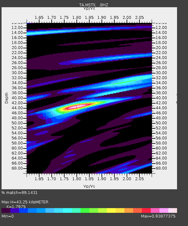
| Estimated Moho Depth: |
43.25 km |
| Estimated Crust Vp/Vs: |
1.80 |
| Assumed Crust Vp: |
6.129 km/s |
| Estimated Crust Vs: |
3.41 km/s |
| Estimated Crust Poisson's Ratio: |
0.28 |
|
| Radial Match: |
99.1431 % |
| Radial Bump: |
224 |
| Transverse Match: |
95.630424 % |
| Transverse Bump: |
400 |
| SOD ConfigId: |
2622 |
| Insert Time: |
2010-03-06 07:46:09.967 +0000 |
| GWidth: |
2.5 |
| Max Bumps: |
400 |
| Tol: |
0.001 |
|
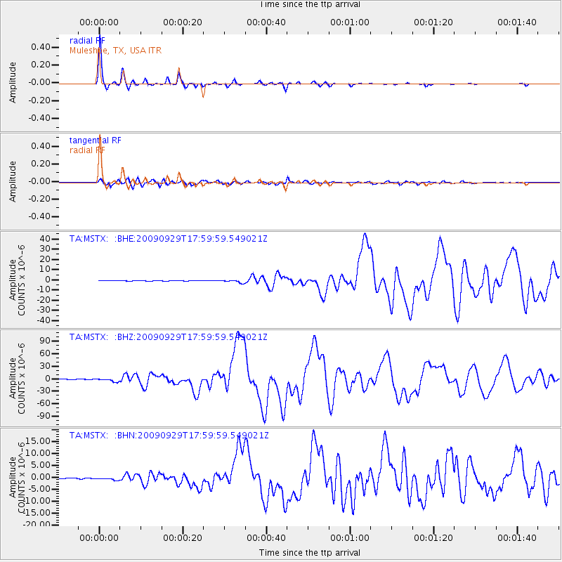
Signal To Noise
| Channel | StoN | STA | LTA |
| TA:MSTX: :BHZ:20090929T17:59:59.549021Z | 20.070576 | 3.976924E-6 | 1.9814696E-7 |
| TA:MSTX: :BHN:20090929T17:59:59.549021Z | 2.3252983 | 4.944479E-7 | 2.1263847E-7 |
| TA:MSTX: :BHE:20090929T17:59:59.549021Z | 8.305323 | 1.3862086E-6 | 1.6690605E-7 |
| Arrivals |
| Ps | 5.8 SECOND |
| PpPs | 19 SECOND |
| PsPs/PpSs | 25 SECOND |


