You are here: Home > Network List > TA - USArray Transportable Network (new EarthScope stations) Stations List
> Station MSTX Muleshoe, TX, USA > Earthquake Result Viewer
MSTX Muleshoe, TX, USA - Earthquake Result Viewer
| Earthquake location: |
Samoa Islands Region |
| Earthquake latitude/longitude: |
-15.8/-172.6 |
| Earthquake time(UTC): |
2009/09/29 (272) 23:45:03 GMT |
| Earthquake Depth: |
10 km |
| Earthquake Magnitude: |
6.0 MB, 5.8 MS |
| Earthquake Catalog/Contributor: |
WHDF/NEIC |
|
| Network: |
TA USArray Transportable Network (new EarthScope stations) |
| Station: |
MSTX Muleshoe, TX, USA |
| Lat/Lon: |
33.97 N/102.77 W |
| Elevation: |
1167 m |
|
| Distance: |
82.8 deg |
| Az: |
51.821 deg |
| Baz: |
245.566 deg |
| Ray Param: |
0.04665074 |
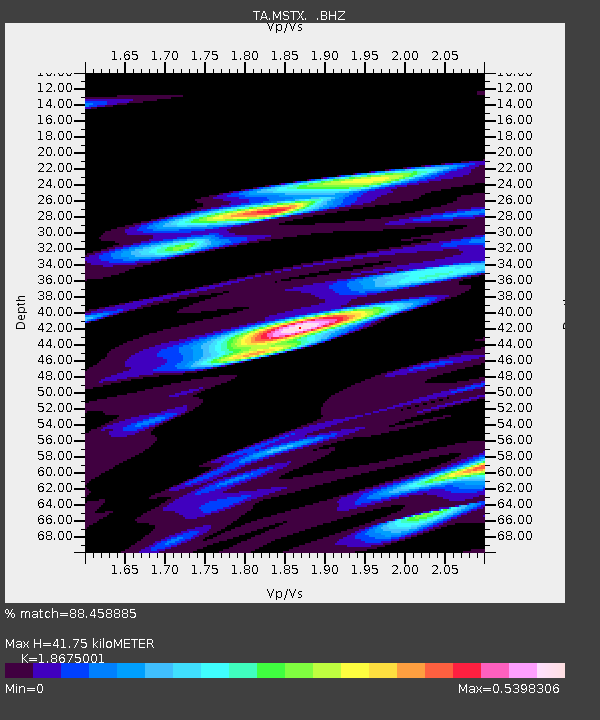
| Estimated Moho Depth: |
41.75 km |
| Estimated Crust Vp/Vs: |
1.87 |
| Assumed Crust Vp: |
6.129 km/s |
| Estimated Crust Vs: |
3.282 km/s |
| Estimated Crust Poisson's Ratio: |
0.30 |
|
| Radial Match: |
88.458885 % |
| Radial Bump: |
288 |
| Transverse Match: |
67.96047 % |
| Transverse Bump: |
400 |
| SOD ConfigId: |
2622 |
| Insert Time: |
2010-03-06 07:46:12.638 +0000 |
| GWidth: |
2.5 |
| Max Bumps: |
400 |
| Tol: |
0.001 |
|

Signal To Noise
| Channel | StoN | STA | LTA |
| TA:MSTX: :BHZ:20090929T23:56:56.150002Z | 3.6005318 | 9.059431E-7 | 2.516137E-7 |
| TA:MSTX: :BHN:20090929T23:56:56.150002Z | 1.2881193 | 1.9041862E-7 | 1.4782684E-7 |
| TA:MSTX: :BHE:20090929T23:56:56.150002Z | 1.1204753 | 2.0590534E-7 | 1.8376608E-7 |
| Arrivals |
| Ps | 6.0 SECOND |
| PpPs | 19 SECOND |
| PsPs/PpSs | 25 SECOND |


