You are here: Home > Network List > CN - Canadian National Seismograph Network Stations List
> Station INK INUVIK, NT > Earthquake Result Viewer
INK INUVIK, NT - Earthquake Result Viewer
*The percent match for this event was below the threshold and hence no stack was calculated.
| Earthquake location: |
North Of Honduras |
| Earthquake latitude/longitude: |
17.5/-83.6 |
| Earthquake time(UTC): |
2018/01/10 (010) 02:51:31 GMT |
| Earthquake Depth: |
33 km |
| Earthquake Magnitude: |
7.8 Mi |
| Earthquake Catalog/Contributor: |
NEIC PDE/pt |
|
| Network: |
CN Canadian National Seismograph Network |
| Station: |
INK INUVIK, NT |
| Lat/Lon: |
68.31 N/133.53 W |
| Elevation: |
44 m |
|
| Distance: |
59.6 deg |
| Az: |
340.733 deg |
| Baz: |
122.119 deg |
| Ray Param: |
$rayparam |
*The percent match for this event was below the threshold and hence was not used in the summary stack. |
|
| Radial Match: |
96.46889 % |
| Radial Bump: |
308 |
| Transverse Match: |
84.08947 % |
| Transverse Bump: |
400 |
| SOD ConfigId: |
13570011 |
| Insert Time: |
2019-04-29 12:58:17.001 +0000 |
| GWidth: |
2.5 |
| Max Bumps: |
400 |
| Tol: |
0.001 |
|
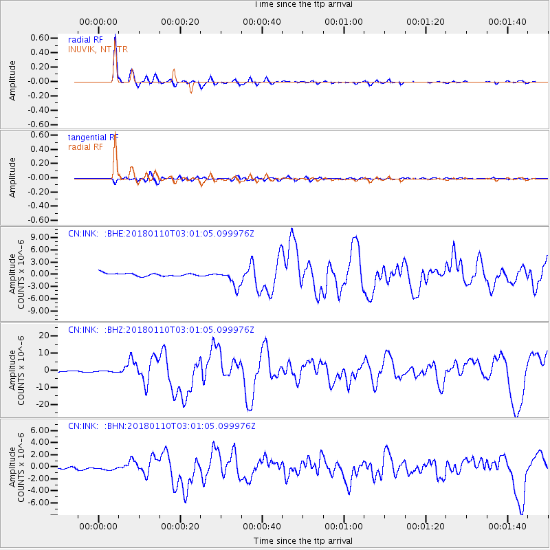
Signal To Noise
| Channel | StoN | STA | LTA |
| CN:INK: :BHZ:20180110T03:01:05.099976Z | 0.60677606 | 2.503472E-7 | 4.1258582E-7 |
| CN:INK: :BHN:20180110T03:01:05.099976Z | 1.5989469 | 2.573888E-7 | 1.6097394E-7 |
| CN:INK: :BHE:20180110T03:01:05.099976Z | 0.49562567 | 1.8657276E-7 | 3.7643886E-7 |
| Arrivals |
| Ps | |
| PpPs | |
| PsPs/PpSs | |


