You are here: Home > Network List > TA - USArray Transportable Network (new EarthScope stations) Stations List
> Station MSTX Muleshoe, TX, USA > Earthquake Result Viewer
MSTX Muleshoe, TX, USA - Earthquake Result Viewer
| Earthquake location: |
South Of Panama |
| Earthquake latitude/longitude: |
5.7/-82.8 |
| Earthquake time(UTC): |
2009/03/12 (071) 23:23:34 GMT |
| Earthquake Depth: |
9.0 km |
| Earthquake Magnitude: |
6.1 MB, 5.9 MS, 6.3 MW, 6.2 MW |
| Earthquake Catalog/Contributor: |
WHDF/NEIC |
|
| Network: |
TA USArray Transportable Network (new EarthScope stations) |
| Station: |
MSTX Muleshoe, TX, USA |
| Lat/Lon: |
33.97 N/102.77 W |
| Elevation: |
1167 m |
|
| Distance: |
33.7 deg |
| Az: |
329.183 deg |
| Baz: |
142.161 deg |
| Ray Param: |
0.078084916 |
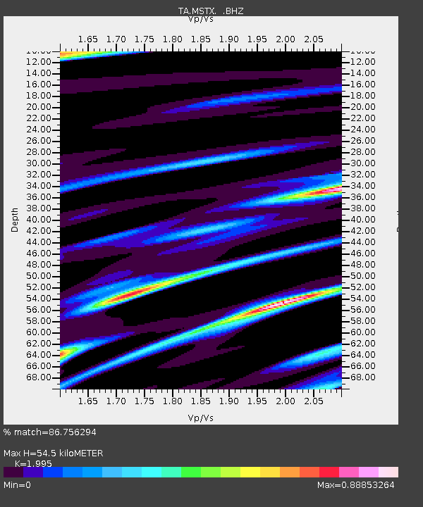
| Estimated Moho Depth: |
54.5 km |
| Estimated Crust Vp/Vs: |
2.00 |
| Assumed Crust Vp: |
6.129 km/s |
| Estimated Crust Vs: |
3.072 km/s |
| Estimated Crust Poisson's Ratio: |
0.33 |
|
| Radial Match: |
86.756294 % |
| Radial Bump: |
310 |
| Transverse Match: |
64.657585 % |
| Transverse Bump: |
390 |
| SOD ConfigId: |
2658 |
| Insert Time: |
2010-03-06 07:46:41.235 +0000 |
| GWidth: |
2.5 |
| Max Bumps: |
400 |
| Tol: |
0.001 |
|
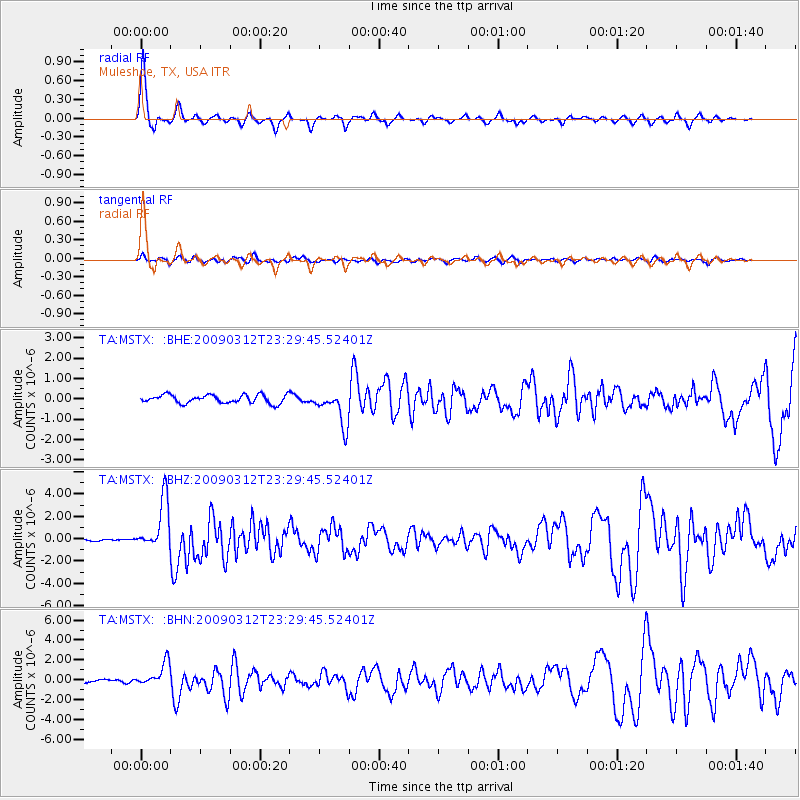
Signal To Noise
| Channel | StoN | STA | LTA |
| TA:MSTX: :BHZ:20090312T23:29:45.52401Z | 12.004359 | 2.259364E-6 | 1.8821197E-7 |
| TA:MSTX: :BHN:20090312T23:29:45.52401Z | 9.365125 | 1.1786839E-6 | 1.2585886E-7 |
| TA:MSTX: :BHE:20090312T23:29:45.52401Z | 4.1947927 | 8.623601E-7 | 2.0557871E-7 |
| Arrivals |
| Ps | 9.4 SECOND |
| PpPs | 25 SECOND |
| PsPs/PpSs | 34 SECOND |


