You are here: Home > Network List > TA - USArray Transportable Network (new EarthScope stations) Stations List
> Station MSTX Muleshoe, TX, USA > Earthquake Result Viewer
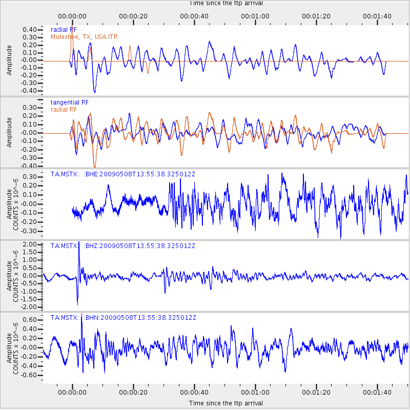
MSTX Muleshoe, TX, USA - Earthquake Result Viewer
*The percent match for this event was below the threshold and hence no stack was calculated.
| Earthquake location: |
Mendoza Province, Argentina |
| Earthquake latitude/longitude: |
-32.1/-69.7 |
| Earthquake time(UTC): |
2009/05/08 (128) 13:44:53 GMT |
| Earthquake Depth: |
112 km |
| Earthquake Magnitude: |
5.6 MB, 5.4 MW |
| Earthquake Catalog/Contributor: |
WHDF/NEIC |
|
| Network: |
TA USArray Transportable Network (new EarthScope stations) |
| Station: |
MSTX Muleshoe, TX, USA |
| Lat/Lon: |
33.97 N/102.77 W |
| Elevation: |
1167 m |
|
| Distance: |
72.7 deg |
| Az: |
331.622 deg |
| Baz: |
150.947 deg |
| Ray Param: |
$rayparam |
*The percent match for this event was below the threshold and hence was not used in the summary stack. |
|
| Radial Match: |
62.2204 % |
| Radial Bump: |
400 |
| Transverse Match: |
74.33928 % |
| Transverse Bump: |
400 |
| SOD ConfigId: |
2658 |
| Insert Time: |
2010-03-06 07:47:01.960 +0000 |
| GWidth: |
2.5 |
| Max Bumps: |
400 |
| Tol: |
0.001 |
|
Signal To Noise
| Channel | StoN | STA | LTA |
| TA:MSTX: :BHZ:20090508T13:55:38.325012Z | 4.942718 | 6.216348E-7 | 1.257678E-7 |
| TA:MSTX: :BHN:20090508T13:55:38.325012Z | 1.7667028 | 2.2260915E-7 | 1.260026E-7 |
| TA:MSTX: :BHE:20090508T13:55:38.325012Z | 1.622366 | 1.1873109E-7 | 7.318391E-8 |
| Arrivals |
| Ps | |
| PpPs | |
| PsPs/PpSs | |


