You are here: Home > Network List > TA - USArray Transportable Network (new EarthScope stations) Stations List
> Station C16K Lisburne Hills, AK, USA > Earthquake Result Viewer
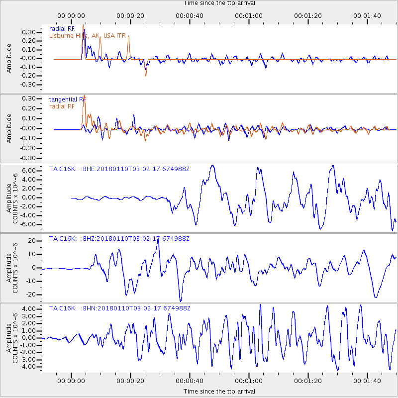
C16K Lisburne Hills, AK, USA - Earthquake Result Viewer
*The percent match for this event was below the threshold and hence no stack was calculated.
| Earthquake location: |
North Of Honduras |
| Earthquake latitude/longitude: |
17.5/-83.6 |
| Earthquake time(UTC): |
2018/01/10 (010) 02:51:31 GMT |
| Earthquake Depth: |
33 km |
| Earthquake Magnitude: |
7.8 Mi |
| Earthquake Catalog/Contributor: |
NEIC PDE/pt |
|
| Network: |
TA USArray Transportable Network (new EarthScope stations) |
| Station: |
C16K Lisburne Hills, AK, USA |
| Lat/Lon: |
68.27 N/165.34 W |
| Elevation: |
102 m |
|
| Distance: |
70.8 deg |
| Az: |
337.039 deg |
| Baz: |
90.926 deg |
| Ray Param: |
$rayparam |
*The percent match for this event was below the threshold and hence was not used in the summary stack. |
|
| Radial Match: |
93.413155 % |
| Radial Bump: |
400 |
| Transverse Match: |
88.98391 % |
| Transverse Bump: |
400 |
| SOD ConfigId: |
13570011 |
| Insert Time: |
2019-04-29 13:01:43.081 +0000 |
| GWidth: |
2.5 |
| Max Bumps: |
400 |
| Tol: |
0.001 |
|
Signal To Noise
| Channel | StoN | STA | LTA |
| TA:C16K: :BHZ:20180110T03:02:17.674988Z | 1.0136741 | 2.544856E-7 | 2.5105265E-7 |
| TA:C16K: :BHN:20180110T03:02:17.674988Z | 3.2650003 | 4.9077966E-7 | 1.5031534E-7 |
| TA:C16K: :BHE:20180110T03:02:17.674988Z | 1.2421719 | 2.7401413E-7 | 2.2059277E-7 |
| Arrivals |
| Ps | |
| PpPs | |
| PsPs/PpSs | |


