You are here: Home > Network List > TA - USArray Transportable Network (new EarthScope stations) Stations List
> Station MSTX Muleshoe, TX, USA > Earthquake Result Viewer
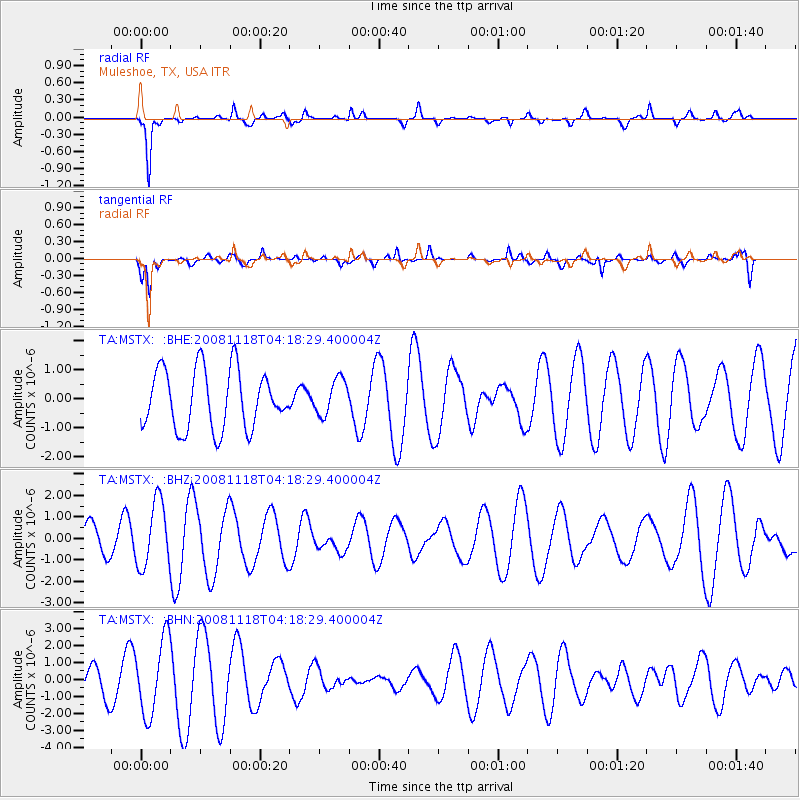
MSTX Muleshoe, TX, USA - Earthquake Result Viewer
*The percent match for this event was below the threshold and hence no stack was calculated.
| Earthquake location: |
Arctic Ocean |
| Earthquake latitude/longitude: |
79.8/-115.9 |
| Earthquake time(UTC): |
2008/11/18 (323) 04:10:35 GMT |
| Earthquake Depth: |
10 km |
| Earthquake Magnitude: |
5.5 ML, 5.2 MB |
| Earthquake Catalog/Contributor: |
WHDF/NEIC |
|
| Network: |
TA USArray Transportable Network (new EarthScope stations) |
| Station: |
MSTX Muleshoe, TX, USA |
| Lat/Lon: |
33.97 N/102.77 W |
| Elevation: |
1167 m |
|
| Distance: |
46.2 deg |
| Az: |
164.877 deg |
| Baz: |
356.782 deg |
| Ray Param: |
$rayparam |
*The percent match for this event was below the threshold and hence was not used in the summary stack. |
|
| Radial Match: |
81.00188 % |
| Radial Bump: |
328 |
| Transverse Match: |
72.785706 % |
| Transverse Bump: |
400 |
| SOD ConfigId: |
2658 |
| Insert Time: |
2010-03-06 07:48:02.822 +0000 |
| GWidth: |
2.5 |
| Max Bumps: |
400 |
| Tol: |
0.001 |
|
Signal To Noise
| Channel | StoN | STA | LTA |
| TA:MSTX: :BHZ:20081118T04:18:29.400004Z | 2.2956476 | 1.5148058E-6 | 6.5985995E-7 |
| TA:MSTX: :BHN:20081118T04:18:29.400004Z | 2.852162 | 2.2066324E-6 | 7.7367014E-7 |
| TA:MSTX: :BHE:20081118T04:18:29.400004Z | 0.61174697 | 6.2017017E-7 | 1.0137692E-6 |
| Arrivals |
| Ps | |
| PpPs | |
| PsPs/PpSs | |


