You are here: Home > Network List > TA - USArray Transportable Network (new EarthScope stations) Stations List
> Station MSTX Muleshoe, TX, USA > Earthquake Result Viewer
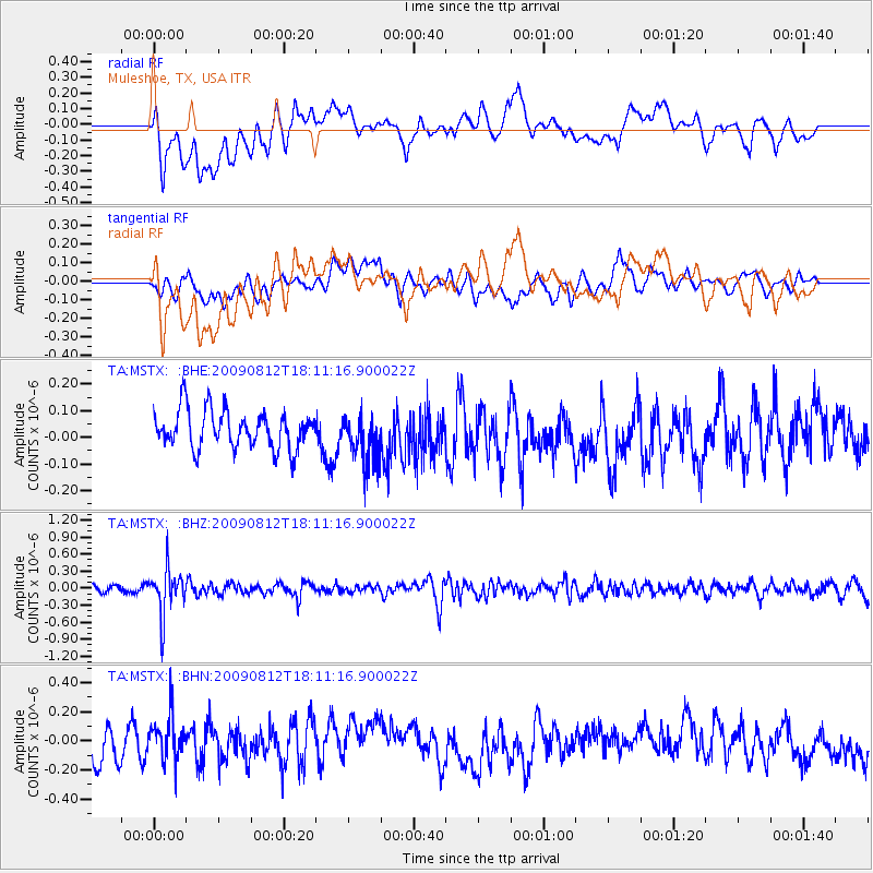
MSTX Muleshoe, TX, USA - Earthquake Result Viewer
*The percent match for this event was below the threshold and hence no stack was calculated.
| Earthquake location: |
Catamarca Province, Argentina |
| Earthquake latitude/longitude: |
-27.9/-66.7 |
| Earthquake time(UTC): |
2009/08/12 (224) 18:00:52 GMT |
| Earthquake Depth: |
174 km |
| Earthquake Magnitude: |
5.5 MW, 5.3 MB, 5.5 MW |
| Earthquake Catalog/Contributor: |
WHDF/NEIC |
|
| Network: |
TA USArray Transportable Network (new EarthScope stations) |
| Station: |
MSTX Muleshoe, TX, USA |
| Lat/Lon: |
33.97 N/102.77 W |
| Elevation: |
1167 m |
|
| Distance: |
70.4 deg |
| Az: |
328.681 deg |
| Baz: |
146.385 deg |
| Ray Param: |
$rayparam |
*The percent match for this event was below the threshold and hence was not used in the summary stack. |
|
| Radial Match: |
59.012108 % |
| Radial Bump: |
400 |
| Transverse Match: |
37.0644 % |
| Transverse Bump: |
400 |
| SOD ConfigId: |
2622 |
| Insert Time: |
2010-03-06 07:48:05.726 +0000 |
| GWidth: |
2.5 |
| Max Bumps: |
400 |
| Tol: |
0.001 |
|
Signal To Noise
| Channel | StoN | STA | LTA |
| TA:MSTX: :BHZ:20090812T18:11:16.900022Z | 6.1566787 | 3.9105305E-7 | 6.351688E-8 |
| TA:MSTX: :BHN:20090812T18:11:16.900022Z | 1.5876578 | 1.4555722E-7 | 9.168048E-8 |
| TA:MSTX: :BHE:20090812T18:11:16.900022Z | 1.3429192 | 9.592431E-8 | 7.142969E-8 |
| Arrivals |
| Ps | |
| PpPs | |
| PsPs/PpSs | |


