You are here: Home > Network List > TA - USArray Transportable Network (new EarthScope stations) Stations List
> Station L19K White Mountain, AK, USA > Earthquake Result Viewer
L19K White Mountain, AK, USA - Earthquake Result Viewer
*The percent match for this event was below the threshold and hence no stack was calculated.
| Earthquake location: |
North Of Honduras |
| Earthquake latitude/longitude: |
17.5/-83.6 |
| Earthquake time(UTC): |
2018/01/10 (010) 02:51:31 GMT |
| Earthquake Depth: |
33 km |
| Earthquake Magnitude: |
7.8 Mi |
| Earthquake Catalog/Contributor: |
NEIC PDE/pt |
|
| Network: |
TA USArray Transportable Network (new EarthScope stations) |
| Station: |
L19K White Mountain, AK, USA |
| Lat/Lon: |
62.18 N/154.85 W |
| Elevation: |
650 m |
|
| Distance: |
65.9 deg |
| Az: |
330.883 deg |
| Baz: |
98.186 deg |
| Ray Param: |
$rayparam |
*The percent match for this event was below the threshold and hence was not used in the summary stack. |
|
| Radial Match: |
92.42955 % |
| Radial Bump: |
400 |
| Transverse Match: |
73.93527 % |
| Transverse Bump: |
400 |
| SOD ConfigId: |
13570011 |
| Insert Time: |
2019-04-29 13:02:54.252 +0000 |
| GWidth: |
2.5 |
| Max Bumps: |
400 |
| Tol: |
0.001 |
|
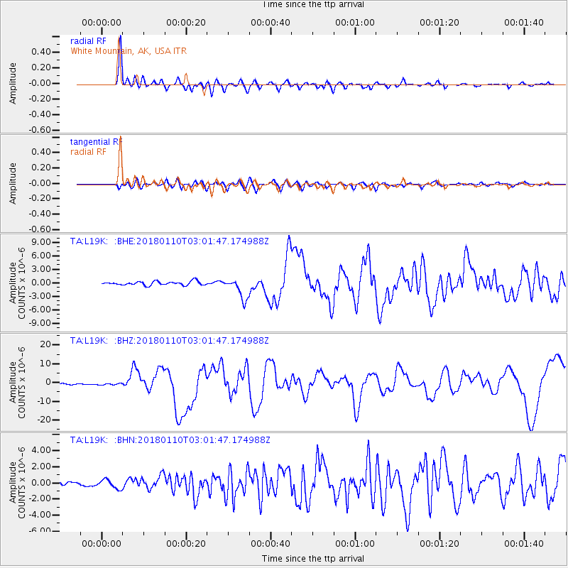
Signal To Noise
| Channel | StoN | STA | LTA |
| TA:L19K: :BHZ:20180110T03:01:47.174988Z | 1.4286629 | 4.0410714E-7 | 2.828569E-7 |
| TA:L19K: :BHN:20180110T03:01:47.174988Z | 1.52076 | 5.8050534E-7 | 3.8172053E-7 |
| TA:L19K: :BHE:20180110T03:01:47.174988Z | 0.9664671 | 3.307136E-7 | 3.4218814E-7 |
| Arrivals |
| Ps | |
| PpPs | |
| PsPs/PpSs | |


