You are here: Home > Network List > TA - USArray Transportable Network (new EarthScope stations) Stations List
> Station MDND Maddock, ND, USA > Earthquake Result Viewer
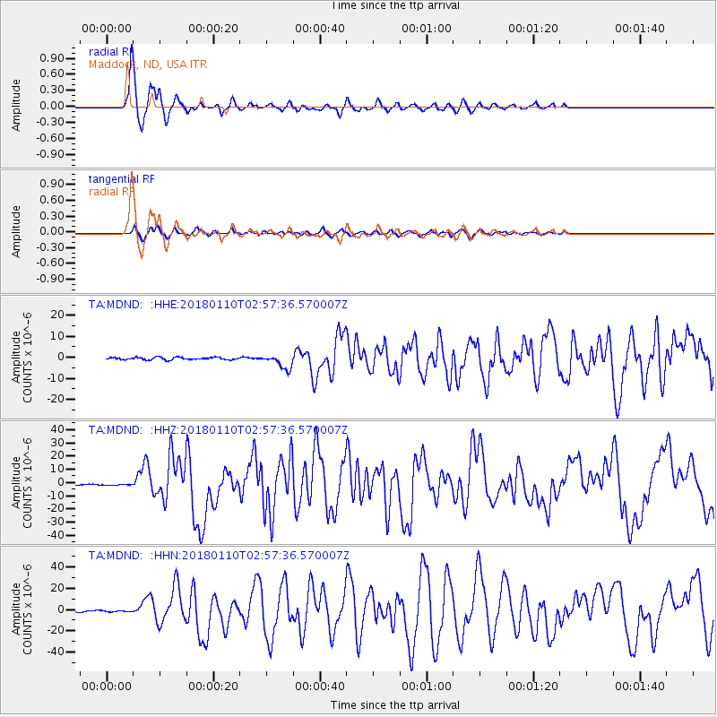
MDND Maddock, ND, USA - Earthquake Result Viewer
*The percent match for this event was below the threshold and hence no stack was calculated.
| Earthquake location: |
North Of Honduras |
| Earthquake latitude/longitude: |
17.5/-83.6 |
| Earthquake time(UTC): |
2018/01/10 (010) 02:51:31 GMT |
| Earthquake Depth: |
33 km |
| Earthquake Magnitude: |
7.8 Mi |
| Earthquake Catalog/Contributor: |
NEIC PDE/pt |
|
| Network: |
TA USArray Transportable Network (new EarthScope stations) |
| Station: |
MDND Maddock, ND, USA |
| Lat/Lon: |
47.85 N/99.60 W |
| Elevation: |
479 m |
|
| Distance: |
33.0 deg |
| Az: |
340.012 deg |
| Baz: |
151.036 deg |
| Ray Param: |
$rayparam |
*The percent match for this event was below the threshold and hence was not used in the summary stack. |
|
| Radial Match: |
96.87547 % |
| Radial Bump: |
313 |
| Transverse Match: |
87.24778 % |
| Transverse Bump: |
400 |
| SOD ConfigId: |
13570011 |
| Insert Time: |
2019-04-29 13:03:06.934 +0000 |
| GWidth: |
2.5 |
| Max Bumps: |
400 |
| Tol: |
0.001 |
|
Signal To Noise
| Channel | StoN | STA | LTA |
| TA:MDND: :HHZ:20180110T02:57:36.570007Z | 0.8187734 | 4.3034896E-7 | 5.2560205E-7 |
| TA:MDND: :HHN:20180110T02:57:36.570007Z | 0.98936915 | 8.367714E-7 | 8.4576254E-7 |
| TA:MDND: :HHE:20180110T02:57:36.570007Z | 0.6757894 | 3.9653864E-7 | 5.867784E-7 |
| Arrivals |
| Ps | |
| PpPs | |
| PsPs/PpSs | |


