You are here: Home > Network List > TA - USArray Transportable Network (new EarthScope stations) Stations List
> Station MSTX Muleshoe, TX, USA > Earthquake Result Viewer
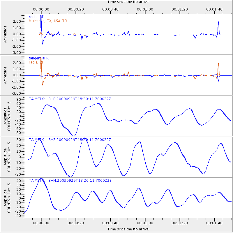
MSTX Muleshoe, TX, USA - Earthquake Result Viewer
*The percent match for this event was below the threshold and hence no stack was calculated.
| Earthquake location: |
Samoa Islands Region |
| Earthquake latitude/longitude: |
-15.6/-172.0 |
| Earthquake time(UTC): |
2009/09/29 (272) 18:08:21 GMT |
| Earthquake Depth: |
10 km |
| Earthquake Magnitude: |
5.6 MB |
| Earthquake Catalog/Contributor: |
WHDF/NEIC |
|
| Network: |
TA USArray Transportable Network (new EarthScope stations) |
| Station: |
MSTX Muleshoe, TX, USA |
| Lat/Lon: |
33.97 N/102.77 W |
| Elevation: |
1167 m |
|
| Distance: |
82.2 deg |
| Az: |
51.663 deg |
| Baz: |
245.46 deg |
| Ray Param: |
$rayparam |
*The percent match for this event was below the threshold and hence was not used in the summary stack. |
|
| Radial Match: |
48.415768 % |
| Radial Bump: |
400 |
| Transverse Match: |
58.106762 % |
| Transverse Bump: |
399 |
| SOD ConfigId: |
2622 |
| Insert Time: |
2010-03-06 07:48:18.383 +0000 |
| GWidth: |
2.5 |
| Max Bumps: |
400 |
| Tol: |
0.001 |
|
Signal To Noise
| Channel | StoN | STA | LTA |
| TA:MSTX: :BHZ:20090929T18:20:11.700022Z | 2.4780529 | 2.5527434E-5 | 1.0301408E-5 |
| TA:MSTX: :BHN:20090929T18:20:11.700022Z | 0.92773527 | 3.8710506E-5 | 4.1725812E-5 |
| TA:MSTX: :BHE:20090929T18:20:11.700022Z | 1.326105 | 6.877054E-5 | 5.185905E-5 |
| Arrivals |
| Ps | |
| PpPs | |
| PsPs/PpSs | |


