You are here: Home > Network List > TA - USArray Transportable Network (new EarthScope stations) Stations List
> Station MSTX Muleshoe, TX, USA > Earthquake Result Viewer
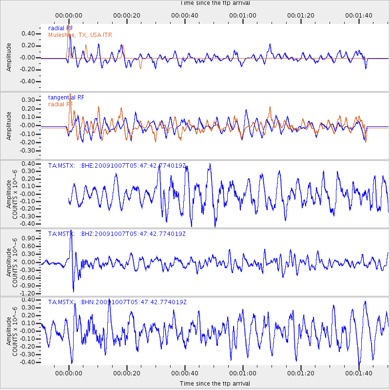
MSTX Muleshoe, TX, USA - Earthquake Result Viewer
*The percent match for this event was below the threshold and hence no stack was calculated.
| Earthquake location: |
Rat Islands, Aleutian Islands |
| Earthquake latitude/longitude: |
52.2/178.1 |
| Earthquake time(UTC): |
2009/10/07 (280) 05:38:37 GMT |
| Earthquake Depth: |
138 km |
| Earthquake Magnitude: |
5.6 MB, 5.6 MW, 5.6 MW |
| Earthquake Catalog/Contributor: |
WHDF/NEIC |
|
| Network: |
TA USArray Transportable Network (new EarthScope stations) |
| Station: |
MSTX Muleshoe, TX, USA |
| Lat/Lon: |
33.97 N/102.77 W |
| Elevation: |
1167 m |
|
| Distance: |
57.7 deg |
| Az: |
74.936 deg |
| Baz: |
314.289 deg |
| Ray Param: |
$rayparam |
*The percent match for this event was below the threshold and hence was not used in the summary stack. |
|
| Radial Match: |
62.248806 % |
| Radial Bump: |
400 |
| Transverse Match: |
51.625698 % |
| Transverse Bump: |
382 |
| SOD ConfigId: |
2622 |
| Insert Time: |
2010-03-06 07:48:21.145 +0000 |
| GWidth: |
2.5 |
| Max Bumps: |
400 |
| Tol: |
0.001 |
|
Signal To Noise
| Channel | StoN | STA | LTA |
| TA:MSTX: :BHZ:20091007T05:47:42.774019Z | 7.297161 | 5.4357497E-7 | 7.44913E-8 |
| TA:MSTX: :BHN:20091007T05:47:42.774019Z | 1.7712427 | 2.0385852E-7 | 1.1509349E-7 |
| TA:MSTX: :BHE:20091007T05:47:42.774019Z | 1.8995025 | 2.034267E-7 | 1.0709473E-7 |
| Arrivals |
| Ps | |
| PpPs | |
| PsPs/PpSs | |


