You are here: Home > Network List > TA - USArray Transportable Network (new EarthScope stations) Stations List
> Station MSTX Muleshoe, TX, USA > Earthquake Result Viewer
MSTX Muleshoe, TX, USA - Earthquake Result Viewer
*The percent match for this event was below the threshold and hence no stack was calculated.
| Earthquake location: |
Santa Cruz Islands |
| Earthquake latitude/longitude: |
-12.4/166.5 |
| Earthquake time(UTC): |
2009/10/12 (285) 09:37:21 GMT |
| Earthquake Depth: |
42 km |
| Earthquake Magnitude: |
5.9 MB, 5.9 MS, 6.2 MW, 6.2 MW |
| Earthquake Catalog/Contributor: |
WHDF/NEIC |
|
| Network: |
TA USArray Transportable Network (new EarthScope stations) |
| Station: |
MSTX Muleshoe, TX, USA |
| Lat/Lon: |
33.97 N/102.77 W |
| Elevation: |
1167 m |
|
| Distance: |
97.4 deg |
| Az: |
56.931 deg |
| Baz: |
260.094 deg |
| Ray Param: |
$rayparam |
*The percent match for this event was below the threshold and hence was not used in the summary stack. |
|
| Radial Match: |
62.67934 % |
| Radial Bump: |
400 |
| Transverse Match: |
56.92613 % |
| Transverse Bump: |
400 |
| SOD ConfigId: |
2622 |
| Insert Time: |
2010-03-06 07:48:29.019 +0000 |
| GWidth: |
2.5 |
| Max Bumps: |
400 |
| Tol: |
0.001 |
|
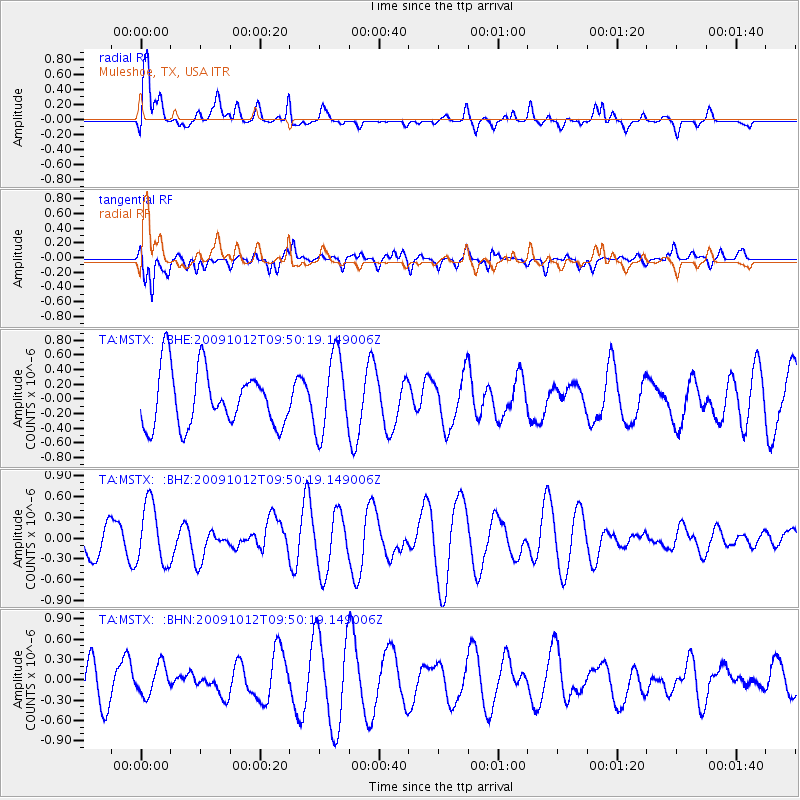
Signal To Noise
| Channel | StoN | STA | LTA |
| TA:MSTX: :BHZ:20091012T09:50:19.149006Z | 2.2522473 | 4.405902E-7 | 1.9562249E-7 |
| TA:MSTX: :BHN:20091012T09:50:19.149006Z | 0.8300125 | 2.1928105E-7 | 2.6419005E-7 |
| TA:MSTX: :BHE:20091012T09:50:19.149006Z | 1.3825114 | 5.33808E-7 | 3.8611472E-7 |
| Arrivals |
| Ps | |
| PpPs | |
| PsPs/PpSs | |


