You are here: Home > Network List > TA - USArray Transportable Network (new EarthScope stations) Stations List
> Station R33M Jennings River, BC, CAN > Earthquake Result Viewer
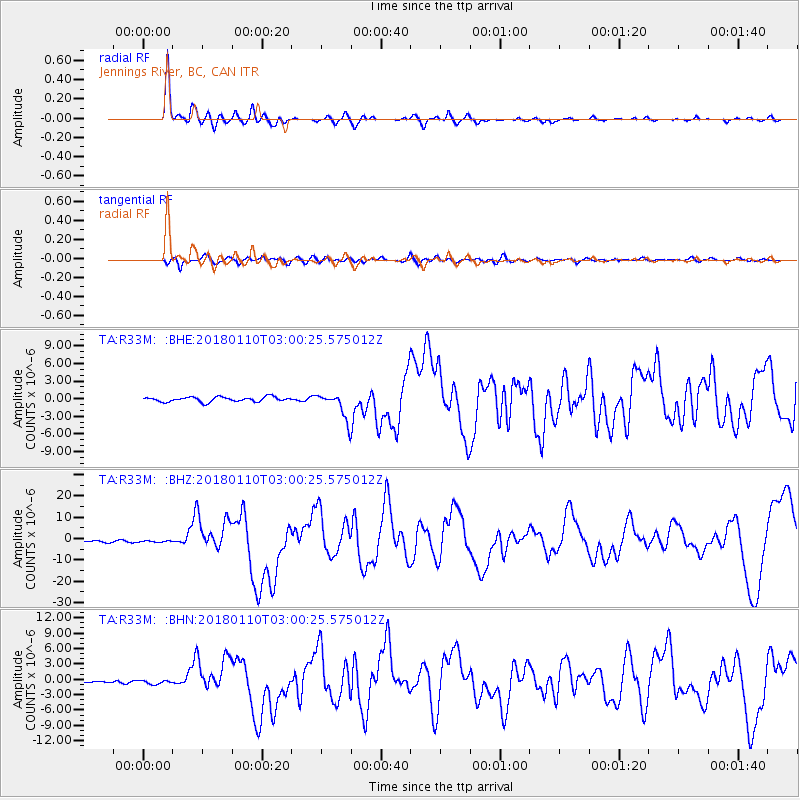
R33M Jennings River, BC, CAN - Earthquake Result Viewer
*The percent match for this event was below the threshold and hence no stack was calculated.
| Earthquake location: |
North Of Honduras |
| Earthquake latitude/longitude: |
17.5/-83.6 |
| Earthquake time(UTC): |
2018/01/10 (010) 02:51:31 GMT |
| Earthquake Depth: |
33 km |
| Earthquake Magnitude: |
7.8 Mi |
| Earthquake Catalog/Contributor: |
NEIC PDE/pt |
|
| Network: |
TA USArray Transportable Network (new EarthScope stations) |
| Station: |
R33M Jennings River, BC, CAN |
| Lat/Lon: |
59.39 N/130.97 W |
| Elevation: |
1437 m |
|
| Distance: |
54.0 deg |
| Az: |
332.264 deg |
| Baz: |
119.775 deg |
| Ray Param: |
$rayparam |
*The percent match for this event was below the threshold and hence was not used in the summary stack. |
|
| Radial Match: |
96.27179 % |
| Radial Bump: |
319 |
| Transverse Match: |
86.1241 % |
| Transverse Bump: |
400 |
| SOD ConfigId: |
13570011 |
| Insert Time: |
2019-04-29 13:03:37.472 +0000 |
| GWidth: |
2.5 |
| Max Bumps: |
400 |
| Tol: |
0.001 |
|
Signal To Noise
| Channel | StoN | STA | LTA |
| TA:R33M: :BHZ:20180110T03:00:25.575012Z | 0.9181863 | 3.4546275E-7 | 3.762447E-7 |
| TA:R33M: :BHN:20180110T03:00:25.575012Z | 2.3352895 | 4.1192936E-7 | 1.7639329E-7 |
| TA:R33M: :BHE:20180110T03:00:25.575012Z | 1.0462776 | 4.1176824E-7 | 3.935554E-7 |
| Arrivals |
| Ps | |
| PpPs | |
| PsPs/PpSs | |


