You are here: Home > Network List > UW - Pacific Northwest Regional Seismic Network Stations List
> Station GNW Green Mountain (BB) > Earthquake Result Viewer
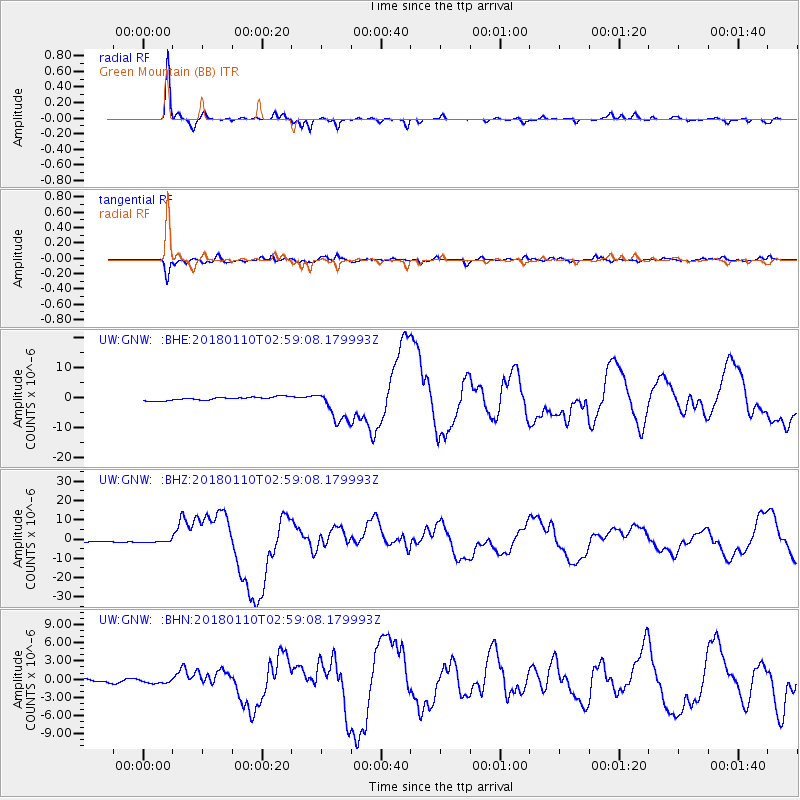
GNW Green Mountain (BB) - Earthquake Result Viewer
*The percent match for this event was below the threshold and hence no stack was calculated.
| Earthquake location: |
North Of Honduras |
| Earthquake latitude/longitude: |
17.5/-83.6 |
| Earthquake time(UTC): |
2018/01/10 (010) 02:51:31 GMT |
| Earthquake Depth: |
33 km |
| Earthquake Magnitude: |
7.8 Mi |
| Earthquake Catalog/Contributor: |
NEIC PDE/pt |
|
| Network: |
UW Pacific Northwest Regional Seismic Network |
| Station: |
GNW Green Mountain (BB) |
| Lat/Lon: |
47.56 N/122.83 W |
| Elevation: |
160 m |
|
| Distance: |
43.9 deg |
| Az: |
321.835 deg |
| Baz: |
119.459 deg |
| Ray Param: |
$rayparam |
*The percent match for this event was below the threshold and hence was not used in the summary stack. |
|
| Radial Match: |
86.23878 % |
| Radial Bump: |
236 |
| Transverse Match: |
73.78248 % |
| Transverse Bump: |
378 |
| SOD ConfigId: |
13570011 |
| Insert Time: |
2019-04-29 13:04:17.580 +0000 |
| GWidth: |
2.5 |
| Max Bumps: |
400 |
| Tol: |
0.001 |
|
Signal To Noise
| Channel | StoN | STA | LTA |
| UW:GNW: :BHZ:20180110T02:59:08.179993Z | 1.6602352 | 8.5626004E-7 | 5.1574625E-7 |
| UW:GNW: :BHN:20180110T02:59:08.179993Z | 1.2924253 | 3.5935363E-7 | 2.7804597E-7 |
| UW:GNW: :BHE:20180110T02:59:08.179993Z | 1.9248594 | 8.7520135E-7 | 4.5468326E-7 |
| Arrivals |
| Ps | |
| PpPs | |
| PsPs/PpSs | |


