You are here: Home > Network List > TA - USArray Transportable Network (new EarthScope stations) Stations List
> Station MSTX Muleshoe, TX, USA > Earthquake Result Viewer
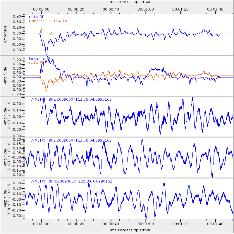
MSTX Muleshoe, TX, USA - Earthquake Result Viewer
*The percent match for this event was below the threshold and hence no stack was calculated.
| Earthquake location: |
South Of Fiji Islands |
| Earthquake latitude/longitude: |
-22.0/-179.6 |
| Earthquake time(UTC): |
2009/06/07 (158) 12:46:30 GMT |
| Earthquake Depth: |
590 km |
| Earthquake Magnitude: |
5.5 MW, 5.1 MB |
| Earthquake Catalog/Contributor: |
WHDF/NEIC |
|
| Network: |
TA USArray Transportable Network (new EarthScope stations) |
| Station: |
MSTX Muleshoe, TX, USA |
| Lat/Lon: |
33.97 N/102.77 W |
| Elevation: |
1167 m |
|
| Distance: |
91.8 deg |
| Az: |
54.052 deg |
| Baz: |
244.661 deg |
| Ray Param: |
$rayparam |
*The percent match for this event was below the threshold and hence was not used in the summary stack. |
|
| Radial Match: |
65.68423 % |
| Radial Bump: |
400 |
| Transverse Match: |
60.702595 % |
| Transverse Bump: |
400 |
| SOD ConfigId: |
2648 |
| Insert Time: |
2010-03-06 07:48:55.996 +0000 |
| GWidth: |
2.5 |
| Max Bumps: |
400 |
| Tol: |
0.001 |
|
Signal To Noise
| Channel | StoN | STA | LTA |
| TA:MSTX: :BHZ:20090607T12:58:04.699016Z | 0.79172117 | 6.19986E-8 | 7.830863E-8 |
| TA:MSTX: :BHN:20090607T12:58:04.699016Z | 1.1466306 | 2.4560825E-7 | 2.1419997E-7 |
| TA:MSTX: :BHE:20090607T12:58:04.699016Z | 0.7421983 | 7.05203E-8 | 9.501544E-8 |
| Arrivals |
| Ps | |
| PpPs | |
| PsPs/PpSs | |


