You are here: Home > Network List > UW - Pacific Northwest Regional Seismic Network Stations List
> Station LON Longmire CREST broad-band > Earthquake Result Viewer
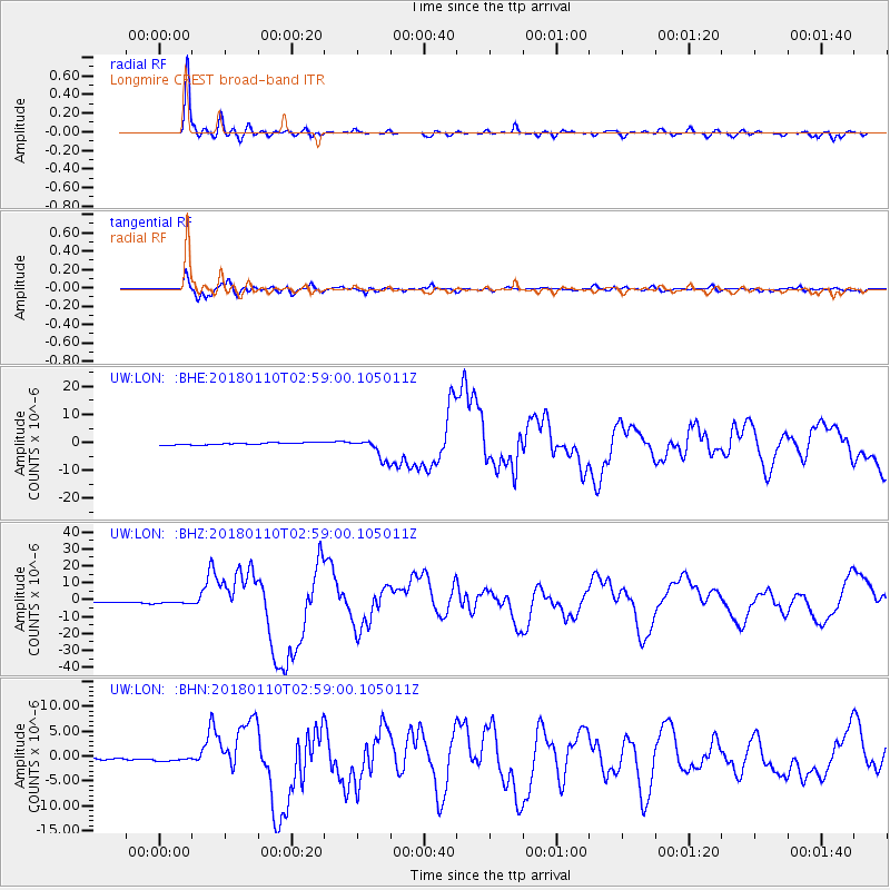
LON Longmire CREST broad-band - Earthquake Result Viewer
*The percent match for this event was below the threshold and hence no stack was calculated.
| Earthquake location: |
North Of Honduras |
| Earthquake latitude/longitude: |
17.5/-83.6 |
| Earthquake time(UTC): |
2018/01/10 (010) 02:51:31 GMT |
| Earthquake Depth: |
33 km |
| Earthquake Magnitude: |
7.8 Mi |
| Earthquake Catalog/Contributor: |
NEIC PDE/pt |
|
| Network: |
UW Pacific Northwest Regional Seismic Network |
| Station: |
LON Longmire CREST broad-band |
| Lat/Lon: |
46.75 N/121.81 W |
| Elevation: |
853 m |
|
| Distance: |
42.9 deg |
| Az: |
321.305 deg |
| Baz: |
119.816 deg |
| Ray Param: |
$rayparam |
*The percent match for this event was below the threshold and hence was not used in the summary stack. |
|
| Radial Match: |
90.83017 % |
| Radial Bump: |
400 |
| Transverse Match: |
86.01302 % |
| Transverse Bump: |
400 |
| SOD ConfigId: |
13570011 |
| Insert Time: |
2019-04-29 13:04:27.366 +0000 |
| GWidth: |
2.5 |
| Max Bumps: |
400 |
| Tol: |
0.001 |
|
Signal To Noise
| Channel | StoN | STA | LTA |
| UW:LON: :BHZ:20180110T02:59:00.105011Z | 2.2665443 | 7.2563944E-7 | 3.201523E-7 |
| UW:LON: :BHN:20180110T02:59:00.105011Z | 3.0863314 | 4.960339E-7 | 1.607196E-7 |
| UW:LON: :BHE:20180110T02:59:00.105011Z | 2.1515615 | 7.411653E-7 | 3.4447785E-7 |
| Arrivals |
| Ps | |
| PpPs | |
| PsPs/PpSs | |


