You are here: Home > Network List > UW - Pacific Northwest Regional Seismic Network Stations List
> Station MRBL Marblemount, WA, USA > Earthquake Result Viewer
MRBL Marblemount, WA, USA - Earthquake Result Viewer
*The percent match for this event was below the threshold and hence no stack was calculated.
| Earthquake location: |
North Of Honduras |
| Earthquake latitude/longitude: |
17.5/-83.6 |
| Earthquake time(UTC): |
2018/01/10 (010) 02:51:31 GMT |
| Earthquake Depth: |
33 km |
| Earthquake Magnitude: |
7.8 Mi |
| Earthquake Catalog/Contributor: |
NEIC PDE/pt |
|
| Network: |
UW Pacific Northwest Regional Seismic Network |
| Station: |
MRBL Marblemount, WA, USA |
| Lat/Lon: |
48.52 N/121.48 W |
| Elevation: |
75 m |
|
| Distance: |
43.6 deg |
| Az: |
323.685 deg |
| Baz: |
121.789 deg |
| Ray Param: |
$rayparam |
*The percent match for this event was below the threshold and hence was not used in the summary stack. |
|
| Radial Match: |
92.03693 % |
| Radial Bump: |
400 |
| Transverse Match: |
77.68469 % |
| Transverse Bump: |
400 |
| SOD ConfigId: |
13570011 |
| Insert Time: |
2019-04-29 13:04:32.094 +0000 |
| GWidth: |
2.5 |
| Max Bumps: |
400 |
| Tol: |
0.001 |
|
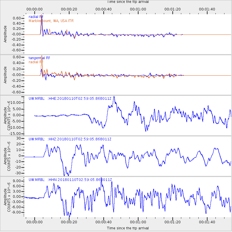
Signal To Noise
| Channel | StoN | STA | LTA |
| UW:MRBL: :HHZ:20180110T02:59:05.868011Z | 1.9842403 | 1.0718647E-6 | 5.40189E-7 |
| UW:MRBL: :HHN:20180110T02:59:05.868011Z | 2.411064 | 5.800235E-7 | 2.4056743E-7 |
| UW:MRBL: :HHE:20180110T02:59:05.868011Z | 2.7289577 | 8.4985015E-7 | 3.1141934E-7 |
| Arrivals |
| Ps | |
| PpPs | |
| PsPs/PpSs | |


