You are here: Home > Network List > TA - USArray Transportable Network (new EarthScope stations) Stations List
> Station B18K Kokolik River, AK, USA > Earthquake Result Viewer
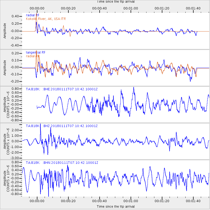
B18K Kokolik River, AK, USA - Earthquake Result Viewer
*The percent match for this event was below the threshold and hence no stack was calculated.
| Earthquake location: |
Iran-Iraq Border Region |
| Earthquake latitude/longitude: |
33.8/45.7 |
| Earthquake time(UTC): |
2018/01/11 (011) 06:59:31 GMT |
| Earthquake Depth: |
10 km |
| Earthquake Magnitude: |
5.5 Mww |
| Earthquake Catalog/Contributor: |
NEIC PDE/us |
|
| Network: |
TA USArray Transportable Network (new EarthScope stations) |
| Station: |
B18K Kokolik River, AK, USA |
| Lat/Lon: |
69.36 N/161.80 W |
| Elevation: |
222 m |
|
| Distance: |
75.2 deg |
| Az: |
9.764 deg |
| Baz: |
336.513 deg |
| Ray Param: |
$rayparam |
*The percent match for this event was below the threshold and hence was not used in the summary stack. |
|
| Radial Match: |
49.897587 % |
| Radial Bump: |
400 |
| Transverse Match: |
58.261127 % |
| Transverse Bump: |
400 |
| SOD ConfigId: |
13570011 |
| Insert Time: |
2019-04-29 13:09:41.953 +0000 |
| GWidth: |
2.5 |
| Max Bumps: |
400 |
| Tol: |
0.001 |
|
Signal To Noise
| Channel | StoN | STA | LTA |
| TA:B18K: :BHZ:20180111T07:10:42.10001Z | 2.4132702 | 9.605733E-7 | 3.98038E-7 |
| TA:B18K: :BHN:20180111T07:10:42.10001Z | 0.85498524 | 2.9064233E-7 | 3.399384E-7 |
| TA:B18K: :BHE:20180111T07:10:42.10001Z | 0.9232992 | 2.4169904E-7 | 2.6177761E-7 |
| Arrivals |
| Ps | |
| PpPs | |
| PsPs/PpSs | |


