You are here: Home > Network List > TA - USArray Transportable Network (new EarthScope stations) Stations List
> Station X26A CR and CF Franklin Farms, Melrose, NM, USA > Earthquake Result Viewer
X26A CR and CF Franklin Farms, Melrose, NM, USA - Earthquake Result Viewer
| Earthquake location: |
Kuril Islands |
| Earthquake latitude/longitude: |
46.0/151.5 |
| Earthquake time(UTC): |
2009/04/07 (097) 04:23:33 GMT |
| Earthquake Depth: |
31 km |
| Earthquake Magnitude: |
6.5 MB, 6.8 MS, 6.9 MW, 6.9 MW |
| Earthquake Catalog/Contributor: |
WHDF/NEIC |
|
| Network: |
TA USArray Transportable Network (new EarthScope stations) |
| Station: |
X26A CR and CF Franklin Farms, Melrose, NM, USA |
| Lat/Lon: |
34.55 N/103.81 W |
| Elevation: |
1393 m |
|
| Distance: |
74.9 deg |
| Az: |
55.791 deg |
| Baz: |
315.749 deg |
| Ray Param: |
0.051953506 |
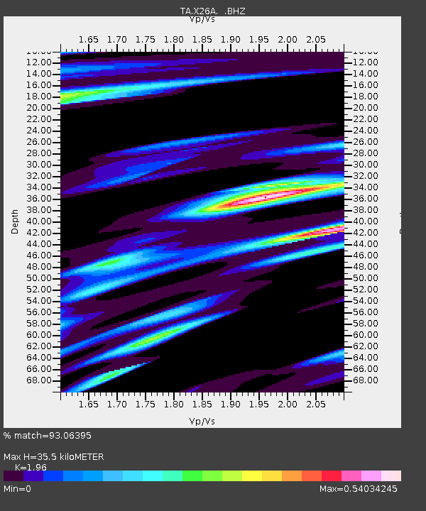
| Estimated Moho Depth: |
35.5 km |
| Estimated Crust Vp/Vs: |
1.96 |
| Assumed Crust Vp: |
6.242 km/s |
| Estimated Crust Vs: |
3.185 km/s |
| Estimated Crust Poisson's Ratio: |
0.32 |
|
| Radial Match: |
93.06395 % |
| Radial Bump: |
355 |
| Transverse Match: |
72.08729 % |
| Transverse Bump: |
400 |
| SOD ConfigId: |
2658 |
| Insert Time: |
2010-03-06 07:49:44.774 +0000 |
| GWidth: |
2.5 |
| Max Bumps: |
400 |
| Tol: |
0.001 |
|

Signal To Noise
| Channel | StoN | STA | LTA |
| TA:X26A: :BHZ:20090407T04:34:40.100012Z | 26.764725 | 4.997939E-6 | 1.8673606E-7 |
| TA:X26A: :BHN:20090407T04:34:40.100012Z | 5.499109 | 1.6213701E-6 | 2.9484235E-7 |
| TA:X26A: :BHE:20090407T04:34:40.100012Z | 5.9208817 | 1.6541017E-6 | 2.7936744E-7 |
| Arrivals |
| Ps | 5.6 SECOND |
| PpPs | 16 SECOND |
| PsPs/PpSs | 22 SECOND |


