You are here: Home > Network List > TA - USArray Transportable Network (new EarthScope stations) Stations List
> Station E20K Nigu River, AK, USA > Earthquake Result Viewer
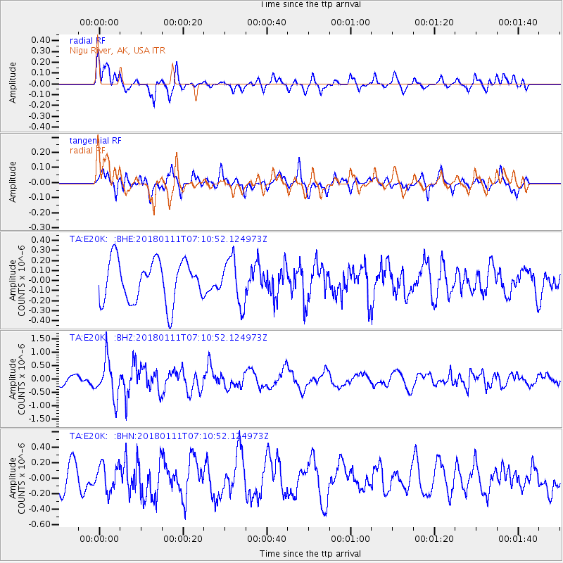
E20K Nigu River, AK, USA - Earthquake Result Viewer
*The percent match for this event was below the threshold and hence no stack was calculated.
| Earthquake location: |
Iran-Iraq Border Region |
| Earthquake latitude/longitude: |
33.8/45.7 |
| Earthquake time(UTC): |
2018/01/11 (011) 06:59:31 GMT |
| Earthquake Depth: |
10 km |
| Earthquake Magnitude: |
5.5 Mww |
| Earthquake Catalog/Contributor: |
NEIC PDE/us |
|
| Network: |
TA USArray Transportable Network (new EarthScope stations) |
| Station: |
E20K Nigu River, AK, USA |
| Lat/Lon: |
68.26 N/156.19 W |
| Elevation: |
866 m |
|
| Distance: |
77.0 deg |
| Az: |
8.214 deg |
| Baz: |
341.37 deg |
| Ray Param: |
$rayparam |
*The percent match for this event was below the threshold and hence was not used in the summary stack. |
|
| Radial Match: |
66.98496 % |
| Radial Bump: |
400 |
| Transverse Match: |
51.046085 % |
| Transverse Bump: |
400 |
| SOD ConfigId: |
13570011 |
| Insert Time: |
2019-04-29 13:09:55.630 +0000 |
| GWidth: |
2.5 |
| Max Bumps: |
400 |
| Tol: |
0.001 |
|
Signal To Noise
| Channel | StoN | STA | LTA |
| TA:E20K: :BHZ:20180111T07:10:52.124973Z | 4.1973977 | 7.270287E-7 | 1.7320939E-7 |
| TA:E20K: :BHN:20180111T07:10:52.124973Z | 0.87718296 | 1.7161848E-7 | 1.956473E-7 |
| TA:E20K: :BHE:20180111T07:10:52.124973Z | 1.1186606 | 2.3019234E-7 | 2.0577497E-7 |
| Arrivals |
| Ps | |
| PpPs | |
| PsPs/PpSs | |


