You are here: Home > Network List > TA - USArray Transportable Network (new EarthScope stations) Stations List
> Station G31M Satah River, YT, CAN > Earthquake Result Viewer
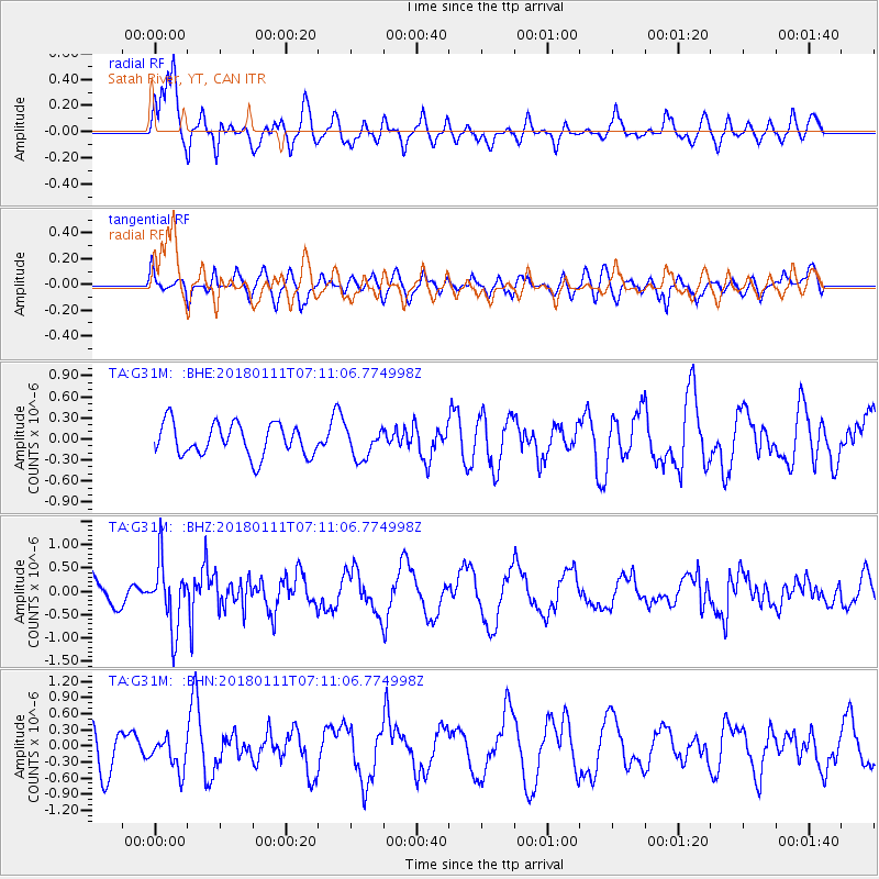
G31M Satah River, YT, CAN - Earthquake Result Viewer
*The percent match for this event was below the threshold and hence no stack was calculated.
| Earthquake location: |
Iran-Iraq Border Region |
| Earthquake latitude/longitude: |
33.8/45.7 |
| Earthquake time(UTC): |
2018/01/11 (011) 06:59:31 GMT |
| Earthquake Depth: |
10 km |
| Earthquake Magnitude: |
5.5 Mww |
| Earthquake Catalog/Contributor: |
NEIC PDE/us |
|
| Network: |
TA USArray Transportable Network (new EarthScope stations) |
| Station: |
G31M Satah River, YT, CAN |
| Lat/Lon: |
66.92 N/134.27 W |
| Elevation: |
61 m |
|
| Distance: |
79.6 deg |
| Az: |
0.008 deg |
| Baz: |
359.983 deg |
| Ray Param: |
$rayparam |
*The percent match for this event was below the threshold and hence was not used in the summary stack. |
|
| Radial Match: |
78.59933 % |
| Radial Bump: |
400 |
| Transverse Match: |
59.78029 % |
| Transverse Bump: |
400 |
| SOD ConfigId: |
13570011 |
| Insert Time: |
2019-04-29 13:10:13.291 +0000 |
| GWidth: |
2.5 |
| Max Bumps: |
400 |
| Tol: |
0.001 |
|
Signal To Noise
| Channel | StoN | STA | LTA |
| TA:G31M: :BHZ:20180111T07:11:06.774998Z | 1.9218507 | 6.9652646E-7 | 3.6242486E-7 |
| TA:G31M: :BHN:20180111T07:11:06.774998Z | 0.5626759 | 3.0055787E-7 | 5.3415806E-7 |
| TA:G31M: :BHE:20180111T07:11:06.774998Z | 0.9005767 | 2.0637054E-7 | 2.2915377E-7 |
| Arrivals |
| Ps | |
| PpPs | |
| PsPs/PpSs | |


