You are here: Home > Network List > TA - USArray Transportable Network (new EarthScope stations) Stations List
> Station P29M Windy Craggy, BC, CAN > Earthquake Result Viewer
P29M Windy Craggy, BC, CAN - Earthquake Result Viewer
| Earthquake location: |
Iran-Iraq Border Region |
| Earthquake latitude/longitude: |
33.8/45.7 |
| Earthquake time(UTC): |
2018/01/11 (011) 06:59:31 GMT |
| Earthquake Depth: |
10 km |
| Earthquake Magnitude: |
5.5 Mww |
| Earthquake Catalog/Contributor: |
NEIC PDE/us |
|
| Network: |
TA USArray Transportable Network (new EarthScope stations) |
| Station: |
P29M Windy Craggy, BC, CAN |
| Lat/Lon: |
59.63 N/137.74 W |
| Elevation: |
679 m |
|
| Distance: |
86.9 deg |
| Az: |
1.774 deg |
| Baz: |
357.091 deg |
| Ray Param: |
0.043709632 |
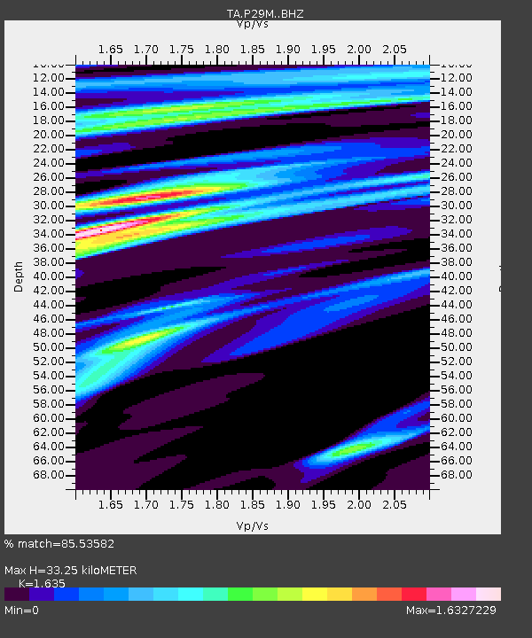
| Estimated Moho Depth: |
33.25 km |
| Estimated Crust Vp/Vs: |
1.63 |
| Assumed Crust Vp: |
6.566 km/s |
| Estimated Crust Vs: |
4.016 km/s |
| Estimated Crust Poisson's Ratio: |
0.20 |
|
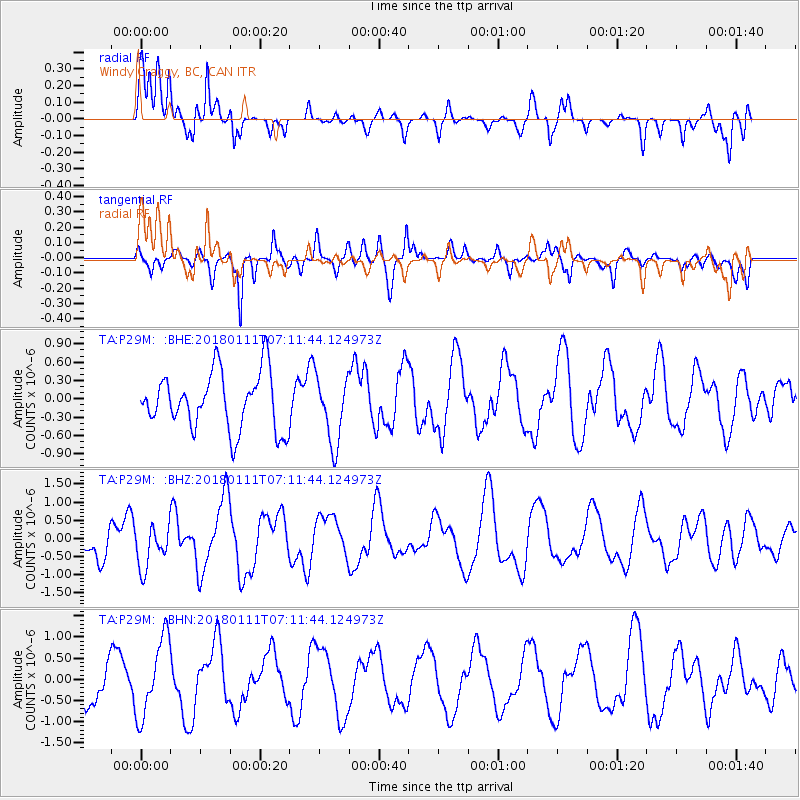
| Radial Match: |
85.53582 % |
| Radial Bump: |
400 |
| Transverse Match: |
62.88687 % |
| Transverse Bump: |
400 |
| SOD ConfigId: |
13570011 |
| Insert Time: |
2019-04-29 13:10:41.027 +0000 |
| GWidth: |
2.5 |
| Max Bumps: |
400 |
| Tol: |
0.001 |
|
Signal To Noise
| Channel | StoN | STA | LTA |
| TA:P29M: :BHZ:20180111T07:11:44.124973Z | 1.3692858 | 5.770507E-7 | 4.2142457E-7 |
| TA:P29M: :BHN:20180111T07:11:44.124973Z | 2.3459914 | 9.2343606E-7 | 3.9362294E-7 |
| TA:P29M: :BHE:20180111T07:11:44.124973Z | 1.1474271 | 5.384741E-7 | 4.6928835E-7 |
| Arrivals |
| Ps | 3.3 SECOND |
| PpPs | 13 SECOND |
| PsPs/PpSs | 16 SECOND |


