You are here: Home > Network List > CN - Canadian National Seismograph Network Stations List
> Station INK INUVIK, NT > Earthquake Result Viewer
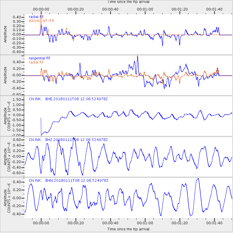
INK INUVIK, NT - Earthquake Result Viewer
*The percent match for this event was below the threshold and hence no stack was calculated.
| Earthquake location: |
Iran-Iraq Border Region |
| Earthquake latitude/longitude: |
33.7/45.7 |
| Earthquake time(UTC): |
2018/01/11 (011) 08:00:39 GMT |
| Earthquake Depth: |
10 km |
| Earthquake Magnitude: |
5.3 Mww |
| Earthquake Catalog/Contributor: |
NEIC PDE/us |
|
| Network: |
CN Canadian National Seismograph Network |
| Station: |
INK INUVIK, NT |
| Lat/Lon: |
68.31 N/133.53 W |
| Elevation: |
44 m |
|
| Distance: |
78.3 deg |
| Az: |
359.707 deg |
| Baz: |
0.657 deg |
| Ray Param: |
$rayparam |
*The percent match for this event was below the threshold and hence was not used in the summary stack. |
|
| Radial Match: |
77.31259 % |
| Radial Bump: |
400 |
| Transverse Match: |
25.719349 % |
| Transverse Bump: |
400 |
| SOD ConfigId: |
13570011 |
| Insert Time: |
2019-04-29 13:12:43.272 +0000 |
| GWidth: |
2.5 |
| Max Bumps: |
400 |
| Tol: |
0.001 |
|
Signal To Noise
| Channel | StoN | STA | LTA |
| CN:INK: :BHZ:20180111T08:12:08.524978Z | 2.453499 | 3.3322956E-7 | 1.3581808E-7 |
| CN:INK: :BHN:20180111T08:12:08.524978Z | 0.68492043 | 1.1288913E-7 | 1.648208E-7 |
| CN:INK: :BHE:20180111T08:12:08.524978Z | 0.68214077 | 4.8607336E-7 | 7.125705E-7 |
| Arrivals |
| Ps | |
| PpPs | |
| PsPs/PpSs | |


