You are here: Home > Network List > TA - USArray Transportable Network (new EarthScope stations) Stations List
> Station X26A CR and CF Franklin Farms, Melrose, NM, USA > Earthquake Result Viewer
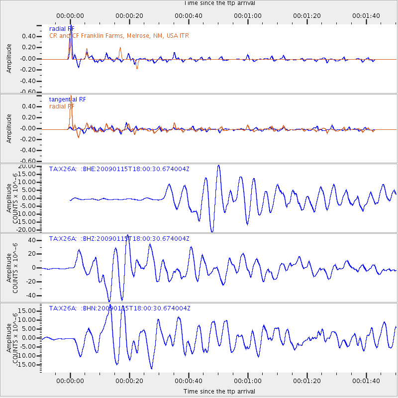
X26A CR and CF Franklin Farms, Melrose, NM, USA - Earthquake Result Viewer
| Earthquake location: |
East Of Kuril Islands |
| Earthquake latitude/longitude: |
46.9/155.2 |
| Earthquake time(UTC): |
2009/01/15 (015) 17:49:39 GMT |
| Earthquake Depth: |
36 km |
| Earthquake Magnitude: |
6.9 MB, 7.5 MS, 7.4 MW, 7.4 MW |
| Earthquake Catalog/Contributor: |
WHDF/NEIC |
|
| Network: |
TA USArray Transportable Network (new EarthScope stations) |
| Station: |
X26A CR and CF Franklin Farms, Melrose, NM, USA |
| Lat/Lon: |
34.55 N/103.81 W |
| Elevation: |
1393 m |
|
| Distance: |
72.4 deg |
| Az: |
58.198 deg |
| Baz: |
315.04 deg |
| Ray Param: |
0.053622823 |
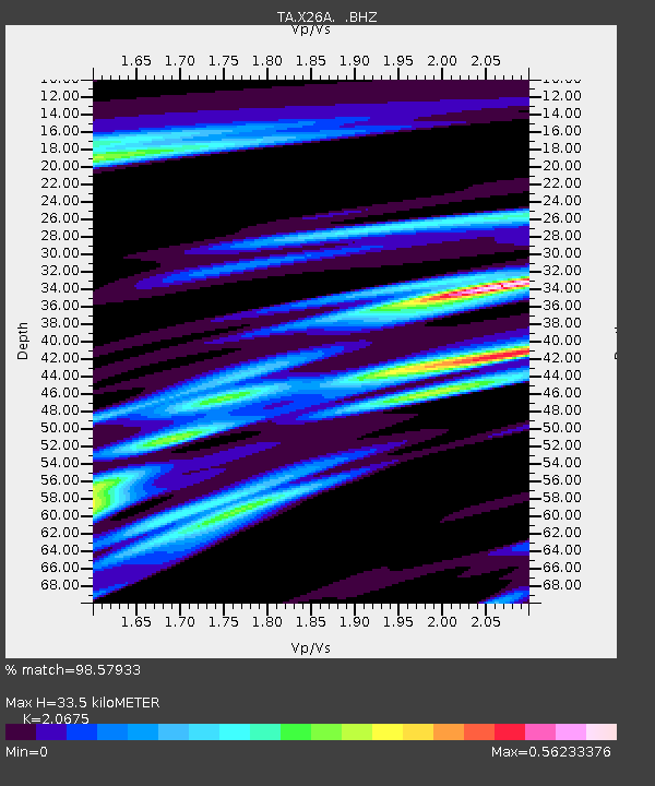
| Estimated Moho Depth: |
33.5 km |
| Estimated Crust Vp/Vs: |
2.07 |
| Assumed Crust Vp: |
6.242 km/s |
| Estimated Crust Vs: |
3.019 km/s |
| Estimated Crust Poisson's Ratio: |
0.35 |
|
| Radial Match: |
98.57933 % |
| Radial Bump: |
308 |
| Transverse Match: |
95.89021 % |
| Transverse Bump: |
400 |
| SOD ConfigId: |
2834 |
| Insert Time: |
2010-03-06 07:50:22.992 +0000 |
| GWidth: |
2.5 |
| Max Bumps: |
400 |
| Tol: |
0.001 |
|
Signal To Noise
| Channel | StoN | STA | LTA |
| TA:X26A: :BHZ:20090115T18:00:30.674004Z | 31.333834 | 1.2932796E-5 | 4.1274222E-7 |
| TA:X26A: :BHN:20090115T18:00:30.674004Z | 13.180729 | 4.7676335E-6 | 3.6171244E-7 |
| TA:X26A: :BHE:20090115T18:00:30.674004Z | 13.463544 | 4.5679826E-6 | 3.392853E-7 |
| Arrivals |
| Ps | 5.9 SECOND |
| PpPs | 16 SECOND |
| PsPs/PpSs | 22 SECOND |


