You are here: Home > Network List > TA - USArray Transportable Network (new EarthScope stations) Stations List
> Station X26A CR and CF Franklin Farms, Melrose, NM, USA > Earthquake Result Viewer
X26A CR and CF Franklin Farms, Melrose, NM, USA - Earthquake Result Viewer
| Earthquake location: |
Southeast Of Honshu, Japan |
| Earthquake latitude/longitude: |
32.8/140.4 |
| Earthquake time(UTC): |
2009/08/12 (224) 22:48:51 GMT |
| Earthquake Depth: |
53 km |
| Earthquake Magnitude: |
6.2 MB, 6.6 MW, 6.6 MW |
| Earthquake Catalog/Contributor: |
WHDF/NEIC |
|
| Network: |
TA USArray Transportable Network (new EarthScope stations) |
| Station: |
X26A CR and CF Franklin Farms, Melrose, NM, USA |
| Lat/Lon: |
34.55 N/103.81 W |
| Elevation: |
1393 m |
|
| Distance: |
89.9 deg |
| Az: |
48.001 deg |
| Baz: |
310.701 deg |
| Ray Param: |
0.041704755 |
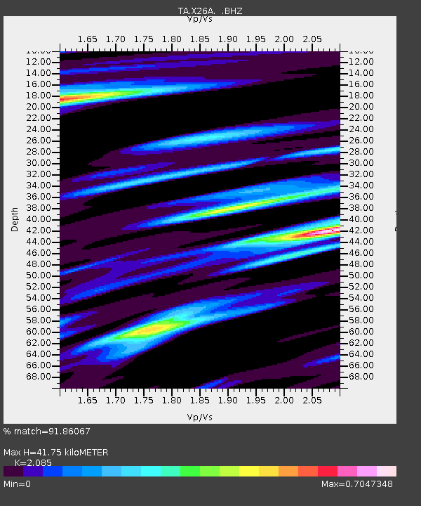
| Estimated Moho Depth: |
41.75 km |
| Estimated Crust Vp/Vs: |
2.09 |
| Assumed Crust Vp: |
6.242 km/s |
| Estimated Crust Vs: |
2.994 km/s |
| Estimated Crust Poisson's Ratio: |
0.35 |
|
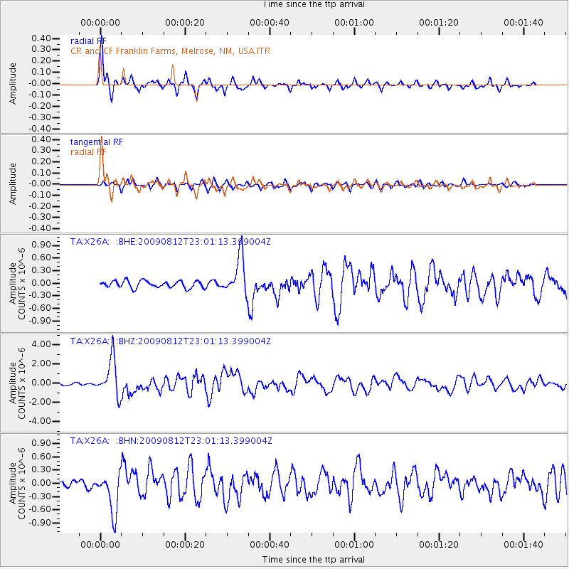
| Radial Match: |
91.86067 % |
| Radial Bump: |
321 |
| Transverse Match: |
82.309006 % |
| Transverse Bump: |
400 |
| SOD ConfigId: |
2622 |
| Insert Time: |
2010-03-06 07:50:32.218 +0000 |
| GWidth: |
2.5 |
| Max Bumps: |
400 |
| Tol: |
0.001 |
|
Signal To Noise
| Channel | StoN | STA | LTA |
| TA:X26A: :BHZ:20090812T23:01:13.399004Z | 23.846268 | 1.9854697E-6 | 8.3261234E-8 |
| TA:X26A: :BHN:20090812T23:01:13.399004Z | 8.965694 | 4.6774858E-7 | 5.2170925E-8 |
| TA:X26A: :BHE:20090812T23:01:13.399004Z | 5.8310366 | 4.7363744E-7 | 8.122697E-8 |
| Arrivals |
| Ps | 7.4 SECOND |
| PpPs | 20 SECOND |
| PsPs/PpSs | 28 SECOND |


