You are here: Home > Network List > TA - USArray Transportable Network (new EarthScope stations) Stations List
> Station R32K Eaglecrest, AK, USA > Earthquake Result Viewer
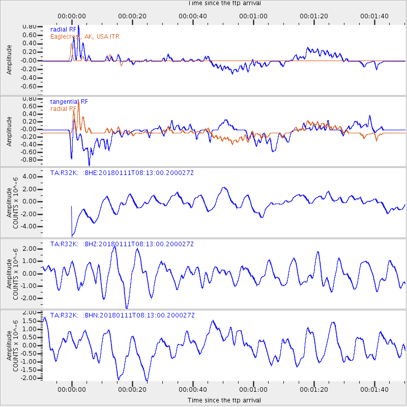
R32K Eaglecrest, AK, USA - Earthquake Result Viewer
*The percent match for this event was below the threshold and hence no stack was calculated.
| Earthquake location: |
Iran-Iraq Border Region |
| Earthquake latitude/longitude: |
33.7/45.7 |
| Earthquake time(UTC): |
2018/01/11 (011) 08:00:39 GMT |
| Earthquake Depth: |
10 km |
| Earthquake Magnitude: |
5.3 Mww |
| Earthquake Catalog/Contributor: |
NEIC PDE/us |
|
| Network: |
TA USArray Transportable Network (new EarthScope stations) |
| Station: |
R32K Eaglecrest, AK, USA |
| Lat/Lon: |
58.27 N/134.52 W |
| Elevation: |
386 m |
|
| Distance: |
88.4 deg |
| Az: |
0.117 deg |
| Baz: |
359.816 deg |
| Ray Param: |
$rayparam |
*The percent match for this event was below the threshold and hence was not used in the summary stack. |
|
| Radial Match: |
71.05726 % |
| Radial Bump: |
400 |
| Transverse Match: |
59.25278 % |
| Transverse Bump: |
400 |
| SOD ConfigId: |
13570011 |
| Insert Time: |
2019-04-29 13:15:39.773 +0000 |
| GWidth: |
2.5 |
| Max Bumps: |
400 |
| Tol: |
0.001 |
|
Signal To Noise
| Channel | StoN | STA | LTA |
| TA:R32K: :BHZ:20180111T08:13:00.200027Z | 0.7290068 | 7.42355E-7 | 1.0183101E-6 |
| TA:R32K: :BHN:20180111T08:13:00.200027Z | 0.313579 | 3.6505602E-7 | 1.1641597E-6 |
| TA:R32K: :BHE:20180111T08:13:00.200027Z | 1.0928137 | 1.6815866E-6 | 1.5387677E-6 |
| Arrivals |
| Ps | |
| PpPs | |
| PsPs/PpSs | |


