You are here: Home > Network List > AZ - ANZA Regional Network Stations List
> Station SMER AZ.SMER > Earthquake Result Viewer
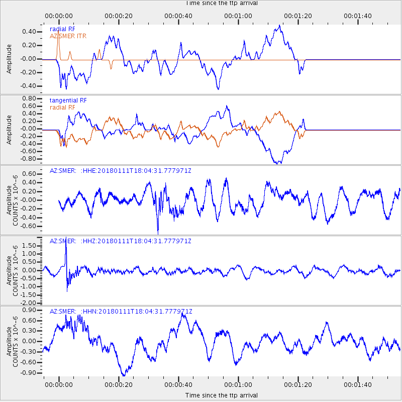
SMER AZ.SMER - Earthquake Result Viewer
*The percent match for this event was below the threshold and hence no stack was calculated.
| Earthquake location: |
South Of Fiji Islands |
| Earthquake latitude/longitude: |
-23.9/180.0 |
| Earthquake time(UTC): |
2018/01/11 (011) 17:53:33 GMT |
| Earthquake Depth: |
508 km |
| Earthquake Magnitude: |
5.5 Mww |
| Earthquake Catalog/Contributor: |
NEIC PDE/us |
|
| Network: |
AZ ANZA Regional Network |
| Station: |
SMER AZ.SMER |
| Lat/Lon: |
33.46 N/117.17 W |
| Elevation: |
355 m |
|
| Distance: |
82.7 deg |
| Az: |
48.607 deg |
| Baz: |
235.208 deg |
| Ray Param: |
$rayparam |
*The percent match for this event was below the threshold and hence was not used in the summary stack. |
|
| Radial Match: |
44.82572 % |
| Radial Bump: |
400 |
| Transverse Match: |
67.17949 % |
| Transverse Bump: |
400 |
| SOD ConfigId: |
13570011 |
| Insert Time: |
2019-04-29 13:17:27.217 +0000 |
| GWidth: |
2.5 |
| Max Bumps: |
400 |
| Tol: |
0.001 |
|
Signal To Noise
| Channel | StoN | STA | LTA |
| AZ:SMER: :HHZ:20180111T18:04:31.777971Z | 2.8808973 | 5.815857E-7 | 2.0187657E-7 |
| AZ:SMER: :HHN:20180111T18:04:31.777971Z | 2.20624 | 5.0150953E-7 | 2.2731415E-7 |
| AZ:SMER: :HHE:20180111T18:04:31.777971Z | 2.4490614 | 3.0386371E-7 | 1.2407354E-7 |
| Arrivals |
| Ps | |
| PpPs | |
| PsPs/PpSs | |


