You are here: Home > Network List > TA - USArray Transportable Network (new EarthScope stations) Stations List
> Station X26A CR and CF Franklin Farms, Melrose, NM, USA > Earthquake Result Viewer
X26A CR and CF Franklin Farms, Melrose, NM, USA - Earthquake Result Viewer
| Earthquake location: |
Galapagos Islands Region |
| Earthquake latitude/longitude: |
2.4/-95.1 |
| Earthquake time(UTC): |
2009/03/15 (074) 03:14:31 GMT |
| Earthquake Depth: |
10 km |
| Earthquake Magnitude: |
5.5 MS, 5.4 MB, 5.8 MW, 5.8 MW |
| Earthquake Catalog/Contributor: |
WHDF/NEIC |
|
| Network: |
TA USArray Transportable Network (new EarthScope stations) |
| Station: |
X26A CR and CF Franklin Farms, Melrose, NM, USA |
| Lat/Lon: |
34.55 N/103.81 W |
| Elevation: |
1393 m |
|
| Distance: |
33.0 deg |
| Az: |
346.758 deg |
| Baz: |
163.902 deg |
| Ray Param: |
0.07842439 |
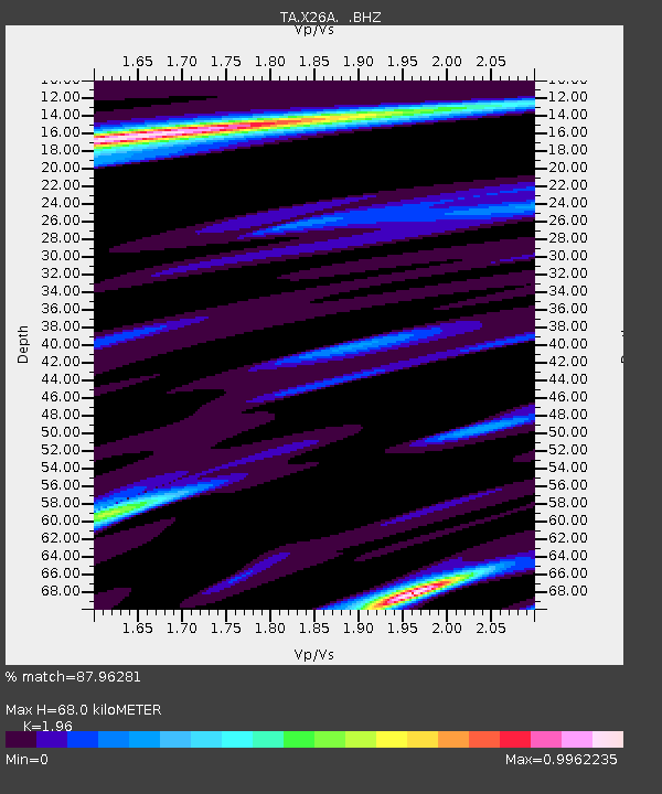
| Estimated Moho Depth: |
68.0 km |
| Estimated Crust Vp/Vs: |
1.96 |
| Assumed Crust Vp: |
6.242 km/s |
| Estimated Crust Vs: |
3.185 km/s |
| Estimated Crust Poisson's Ratio: |
0.32 |
|
| Radial Match: |
87.96281 % |
| Radial Bump: |
199 |
| Transverse Match: |
51.45196 % |
| Transverse Bump: |
321 |
| SOD ConfigId: |
2658 |
| Insert Time: |
2010-03-06 07:51:02.180 +0000 |
| GWidth: |
2.5 |
| Max Bumps: |
400 |
| Tol: |
0.001 |
|

Signal To Noise
| Channel | StoN | STA | LTA |
| TA:X26A: :BHZ:20090315T03:20:35.998989Z | 5.159314 | 6.0826267E-7 | 1.1789603E-7 |
| TA:X26A: :BHN:20090315T03:20:35.998989Z | 3.4726458 | 3.8193645E-7 | 1.0998428E-7 |
| TA:X26A: :BHE:20090315T03:20:35.998989Z | 0.7001658 | 1.8012891E-7 | 2.5726607E-7 |
| Arrivals |
| Ps | 11 SECOND |
| PpPs | 30 SECOND |
| PsPs/PpSs | 41 SECOND |


