You are here: Home > Network List > TA - USArray Transportable Network (new EarthScope stations) Stations List
> Station X26A CR and CF Franklin Farms, Melrose, NM, USA > Earthquake Result Viewer
X26A CR and CF Franklin Farms, Melrose, NM, USA - Earthquake Result Viewer
| Earthquake location: |
Tonga Islands Region |
| Earthquake latitude/longitude: |
-23.0/-174.7 |
| Earthquake time(UTC): |
2009/03/19 (078) 18:17:40 GMT |
| Earthquake Depth: |
34 km |
| Earthquake Magnitude: |
7.0 MB, 7.6 MS, 7.6 MW, 7.6 MW |
| Earthquake Catalog/Contributor: |
WHDF/NEIC |
|
| Network: |
TA USArray Transportable Network (new EarthScope stations) |
| Station: |
X26A CR and CF Franklin Farms, Melrose, NM, USA |
| Lat/Lon: |
34.55 N/103.81 W |
| Elevation: |
1393 m |
|
| Distance: |
88.3 deg |
| Az: |
51.266 deg |
| Baz: |
240.521 deg |
| Ray Param: |
0.042645227 |
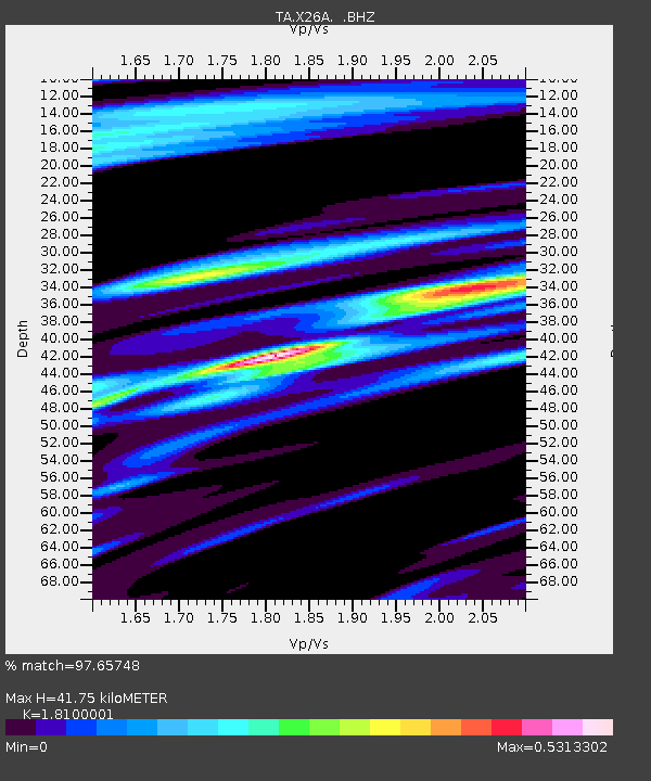
| Estimated Moho Depth: |
41.75 km |
| Estimated Crust Vp/Vs: |
1.81 |
| Assumed Crust Vp: |
6.242 km/s |
| Estimated Crust Vs: |
3.449 km/s |
| Estimated Crust Poisson's Ratio: |
0.28 |
|
| Radial Match: |
97.65748 % |
| Radial Bump: |
322 |
| Transverse Match: |
92.742195 % |
| Transverse Bump: |
400 |
| SOD ConfigId: |
2658 |
| Insert Time: |
2010-03-06 07:51:07.846 +0000 |
| GWidth: |
2.5 |
| Max Bumps: |
400 |
| Tol: |
0.001 |
|

Signal To Noise
| Channel | StoN | STA | LTA |
| TA:X26A: :BHZ:20090319T18:29:57.725002Z | 26.064463 | 6.9161865E-6 | 2.6534929E-7 |
| TA:X26A: :BHN:20090319T18:29:57.725002Z | 9.026973 | 8.691849E-7 | 9.628753E-8 |
| TA:X26A: :BHE:20090319T18:29:57.725002Z | 11.89947 | 1.9108131E-6 | 1.6057967E-7 |
| Arrivals |
| Ps | 5.5 SECOND |
| PpPs | 18 SECOND |
| PsPs/PpSs | 24 SECOND |


