You are here: Home > Network List > CI - Caltech Regional Seismic Network Stations List
> Station SWS Sam W. Stewart, Westmorland, CA, USA > Earthquake Result Viewer
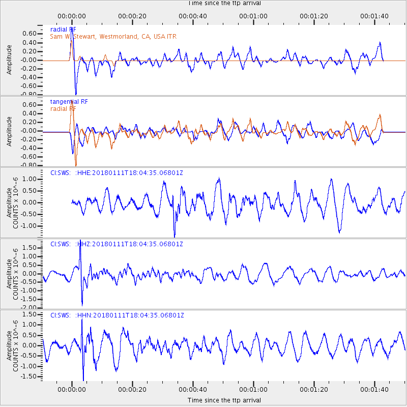
SWS Sam W. Stewart, Westmorland, CA, USA - Earthquake Result Viewer
*The percent match for this event was below the threshold and hence no stack was calculated.
| Earthquake location: |
South Of Fiji Islands |
| Earthquake latitude/longitude: |
-23.9/180.0 |
| Earthquake time(UTC): |
2018/01/11 (011) 17:53:33 GMT |
| Earthquake Depth: |
508 km |
| Earthquake Magnitude: |
5.5 Mww |
| Earthquake Catalog/Contributor: |
NEIC PDE/us |
|
| Network: |
CI Caltech Regional Seismic Network |
| Station: |
SWS Sam W. Stewart, Westmorland, CA, USA |
| Lat/Lon: |
32.94 N/115.80 W |
| Elevation: |
140 m |
|
| Distance: |
83.3 deg |
| Az: |
49.691 deg |
| Baz: |
236.089 deg |
| Ray Param: |
$rayparam |
*The percent match for this event was below the threshold and hence was not used in the summary stack. |
|
| Radial Match: |
67.96903 % |
| Radial Bump: |
400 |
| Transverse Match: |
48.550602 % |
| Transverse Bump: |
400 |
| SOD ConfigId: |
13570011 |
| Insert Time: |
2019-04-29 13:18:36.920 +0000 |
| GWidth: |
2.5 |
| Max Bumps: |
400 |
| Tol: |
0.001 |
|
Signal To Noise
| Channel | StoN | STA | LTA |
| CI:SWS: :HHZ:20180111T18:04:35.06801Z | 4.333501 | 7.322848E-7 | 1.6898225E-7 |
| CI:SWS: :HHN:20180111T18:04:35.06801Z | 1.1056181 | 5.0243176E-7 | 4.5443514E-7 |
| CI:SWS: :HHE:20180111T18:04:35.06801Z | 2.5735214 | 6.1845736E-7 | 2.4031561E-7 |
| Arrivals |
| Ps | |
| PpPs | |
| PsPs/PpSs | |


