You are here: Home > Network List > BK - Berkeley Digital Seismograph Network Stations List
> Station MCCM Marconi Conference Center, Marshall, CA, USA > Earthquake Result Viewer
MCCM Marconi Conference Center, Marshall, CA, USA - Earthquake Result Viewer
| Earthquake location: |
Near Coast Of Ecuador |
| Earthquake latitude/longitude: |
0.4/-79.9 |
| Earthquake time(UTC): |
2016/04/16 (107) 23:58:37 GMT |
| Earthquake Depth: |
19 km |
| Earthquake Magnitude: |
7.8 MWW, 7.4 MI |
| Earthquake Catalog/Contributor: |
NEIC PDE/NEIC COMCAT |
|
| Network: |
BK Berkeley Digital Seismograph Network |
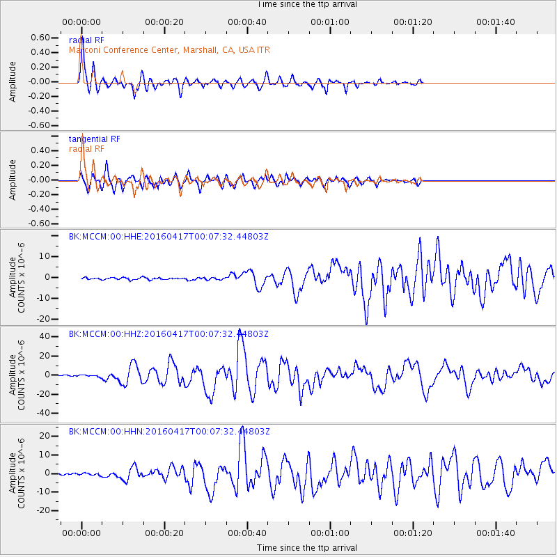
| Station: |
MCCM Marconi Conference Center, Marshall, CA, USA |
| Lat/Lon: |
38.14 N/122.88 W |
| Elevation: |
-7.7 m |
|
| Distance: |
54.5 deg |
| Az: |
318.698 deg |
| Baz: |
123.165 deg |
| Ray Param: |
0.06540775 |
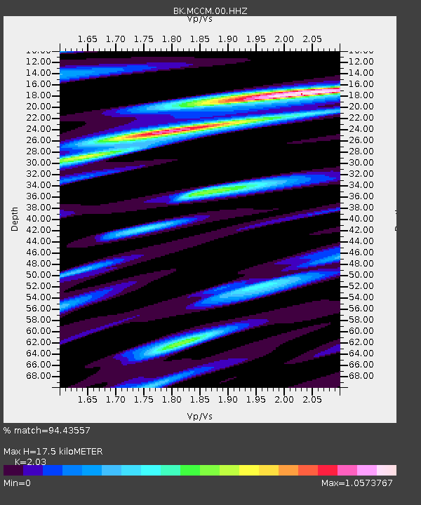
| Estimated Moho Depth: |
17.5 km |
| Estimated Crust Vp/Vs: |
2.03 |
| Assumed Crust Vp: |
6.472 km/s |
| Estimated Crust Vs: |
3.188 km/s |
| Estimated Crust Poisson's Ratio: |
0.34 |
|
| Radial Match: |
94.43557 % |
| Radial Bump: |
364 |
| Transverse Match: |
89.30386 % |
| Transverse Bump: |
400 |
| SOD ConfigId: |
1475611 |
| Insert Time: |
2016-04-30 23:59:54.275 +0000 |
| GWidth: |
2.5 |
| Max Bumps: |
400 |
| Tol: |
0.001 |
|
Signal To Noise
| Channel | StoN | STA | LTA |
| BK:MCCM:00:HHZ:20160417T00:07:32.44803Z | 2.3505864 | 8.716905E-7 | 3.708396E-7 |
| BK:MCCM:00:HHN:20160417T00:07:32.44803Z | 1.2963501 | 5.449406E-7 | 4.203653E-7 |
| BK:MCCM:00:HHE:20160417T00:07:32.44803Z | 1.0306777 | 4.819951E-7 | 4.676487E-7 |
| Arrivals |
| Ps | 2.9 SECOND |
| PpPs | 7.8 SECOND |
| PsPs/PpSs | 11 SECOND |


