You are here: Home > Network List > TA - USArray Transportable Network (new EarthScope stations) Stations List
> Station A22K Sinclair Lake, AK, USA > Earthquake Result Viewer
A22K Sinclair Lake, AK, USA - Earthquake Result Viewer
| Earthquake location: |
Myanmar |
| Earthquake latitude/longitude: |
18.4/96.1 |
| Earthquake time(UTC): |
2018/01/11 (011) 18:26:24 GMT |
| Earthquake Depth: |
10 km |
| Earthquake Magnitude: |
6.0 Mww |
| Earthquake Catalog/Contributor: |
NEIC PDE/us |
|
| Network: |
TA USArray Transportable Network (new EarthScope stations) |
| Station: |
A22K Sinclair Lake, AK, USA |
| Lat/Lon: |
71.00 N/154.97 W |
| Elevation: |
6.0 m |
|
| Distance: |
78.8 deg |
| Az: |
18.408 deg |
| Baz: |
293.678 deg |
| Ray Param: |
0.049421906 |
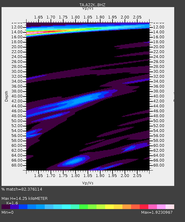
| Estimated Moho Depth: |
14.25 km |
| Estimated Crust Vp/Vs: |
1.60 |
| Assumed Crust Vp: |
5.782 km/s |
| Estimated Crust Vs: |
3.614 km/s |
| Estimated Crust Poisson's Ratio: |
0.18 |
|
| Radial Match: |
82.376114 % |
| Radial Bump: |
400 |
| Transverse Match: |
68.48191 % |
| Transverse Bump: |
400 |
| SOD ConfigId: |
13570011 |
| Insert Time: |
2019-04-29 13:25:33.084 +0000 |
| GWidth: |
2.5 |
| Max Bumps: |
400 |
| Tol: |
0.001 |
|
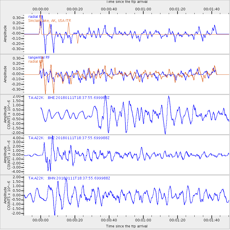
Signal To Noise
| Channel | StoN | STA | LTA |
| TA:A22K: :BHZ:20180111T18:37:55.699988Z | 5.879382 | 1.5649633E-6 | 2.661782E-7 |
| TA:A22K: :BHN:20180111T18:37:55.699988Z | 2.337336 | 4.79022E-7 | 2.0494355E-7 |
| TA:A22K: :BHE:20180111T18:37:55.699988Z | 2.162964 | 7.6485105E-7 | 3.5361245E-7 |
| Arrivals |
| Ps | 1.5 SECOND |
| PpPs | 6.2 SECOND |
| PsPs/PpSs | 7.8 SECOND |


