You are here: Home > Network List > TA - USArray Transportable Network (new EarthScope stations) Stations List
> Station F26K Sheenjek River, AK, USA > Earthquake Result Viewer
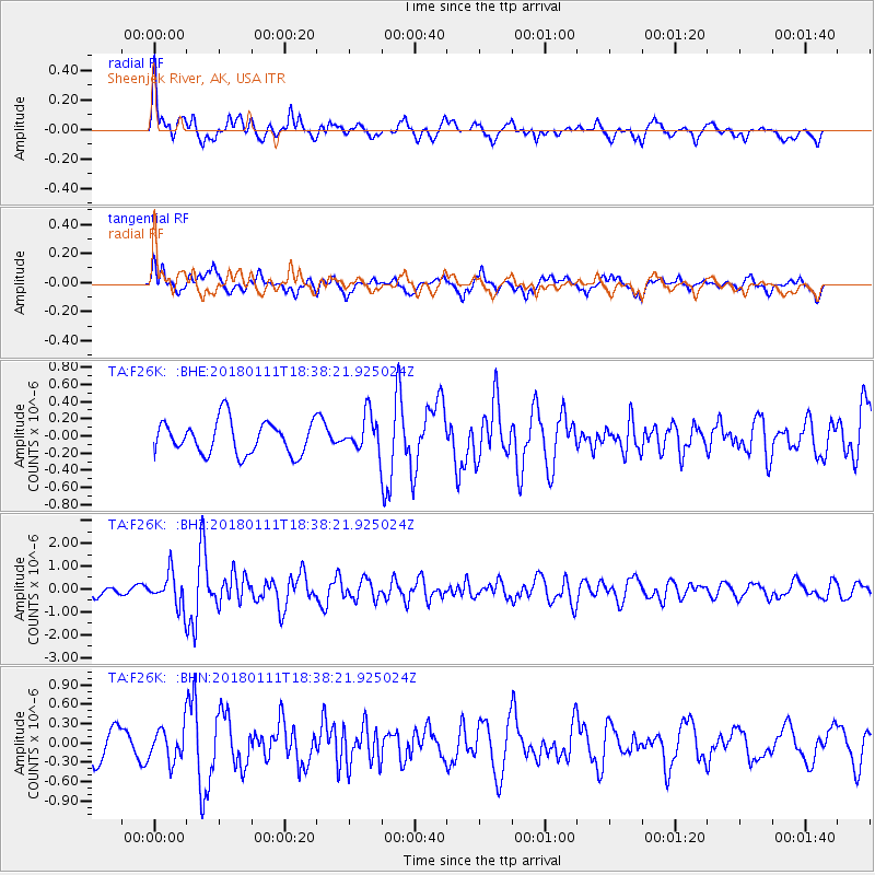
F26K Sheenjek River, AK, USA - Earthquake Result Viewer
*The percent match for this event was below the threshold and hence no stack was calculated.
| Earthquake location: |
Myanmar |
| Earthquake latitude/longitude: |
18.4/96.1 |
| Earthquake time(UTC): |
2018/01/11 (011) 18:26:24 GMT |
| Earthquake Depth: |
10 km |
| Earthquake Magnitude: |
6.0 Mww |
| Earthquake Catalog/Contributor: |
NEIC PDE/us |
|
| Network: |
TA USArray Transportable Network (new EarthScope stations) |
| Station: |
F26K Sheenjek River, AK, USA |
| Lat/Lon: |
67.69 N/144.15 W |
| Elevation: |
683 m |
|
| Distance: |
83.7 deg |
| Az: |
19.471 deg |
| Baz: |
303.972 deg |
| Ray Param: |
$rayparam |
*The percent match for this event was below the threshold and hence was not used in the summary stack. |
|
| Radial Match: |
72.15415 % |
| Radial Bump: |
400 |
| Transverse Match: |
58.82279 % |
| Transverse Bump: |
400 |
| SOD ConfigId: |
13570011 |
| Insert Time: |
2019-04-29 13:26:06.108 +0000 |
| GWidth: |
2.5 |
| Max Bumps: |
400 |
| Tol: |
0.001 |
|
Signal To Noise
| Channel | StoN | STA | LTA |
| TA:F26K: :BHZ:20180111T18:38:21.925024Z | 3.710298 | 7.354288E-7 | 1.9821286E-7 |
| TA:F26K: :BHN:20180111T18:38:21.925024Z | 1.4729782 | 2.546577E-7 | 1.7288625E-7 |
| TA:F26K: :BHE:20180111T18:38:21.925024Z | 1.0867772 | 2.091773E-7 | 1.9247487E-7 |
| Arrivals |
| Ps | |
| PpPs | |
| PsPs/PpSs | |


