You are here: Home > Network List > TA - USArray Transportable Network (new EarthScope stations) Stations List
> Station G31M Satah River, YT, CAN > Earthquake Result Viewer
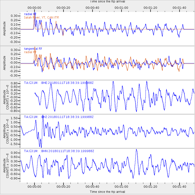
G31M Satah River, YT, CAN - Earthquake Result Viewer
*The percent match for this event was below the threshold and hence no stack was calculated.
| Earthquake location: |
Myanmar |
| Earthquake latitude/longitude: |
18.4/96.1 |
| Earthquake time(UTC): |
2018/01/11 (011) 18:26:24 GMT |
| Earthquake Depth: |
10 km |
| Earthquake Magnitude: |
6.0 Mww |
| Earthquake Catalog/Contributor: |
NEIC PDE/us |
|
| Network: |
TA USArray Transportable Network (new EarthScope stations) |
| Station: |
G31M Satah River, YT, CAN |
| Lat/Lon: |
66.92 N/134.27 W |
| Elevation: |
61 m |
|
| Distance: |
87.2 deg |
| Az: |
17.691 deg |
| Baz: |
312.936 deg |
| Ray Param: |
$rayparam |
*The percent match for this event was below the threshold and hence was not used in the summary stack. |
|
| Radial Match: |
52.909843 % |
| Radial Bump: |
378 |
| Transverse Match: |
50.786983 % |
| Transverse Bump: |
383 |
| SOD ConfigId: |
13570011 |
| Insert Time: |
2019-04-29 13:26:17.562 +0000 |
| GWidth: |
2.5 |
| Max Bumps: |
400 |
| Tol: |
0.001 |
|
Signal To Noise
| Channel | StoN | STA | LTA |
| TA:G31M: :BHZ:20180111T18:38:39.199988Z | 2.8545809 | 9.553125E-7 | 3.346595E-7 |
| TA:G31M: :BHN:20180111T18:38:39.199988Z | 1.4210165 | 5.283246E-7 | 3.7179345E-7 |
| TA:G31M: :BHE:20180111T18:38:39.199988Z | 1.0776792 | 3.8570747E-7 | 3.5790563E-7 |
| Arrivals |
| Ps | |
| PpPs | |
| PsPs/PpSs | |


