You are here: Home > Network List > TA - USArray Transportable Network (new EarthScope stations) Stations List
> Station I30M Mount Dempster, Yukon, CAN > Earthquake Result Viewer
I30M Mount Dempster, Yukon, CAN - Earthquake Result Viewer
*The percent match for this event was below the threshold and hence no stack was calculated.
| Earthquake location: |
Myanmar |
| Earthquake latitude/longitude: |
18.4/96.1 |
| Earthquake time(UTC): |
2018/01/11 (011) 18:26:24 GMT |
| Earthquake Depth: |
10 km |
| Earthquake Magnitude: |
6.0 Mww |
| Earthquake Catalog/Contributor: |
NEIC PDE/us |
|
| Network: |
TA USArray Transportable Network (new EarthScope stations) |
| Station: |
I30M Mount Dempster, Yukon, CAN |
| Lat/Lon: |
65.22 N/136.38 W |
| Elevation: |
1399 m |
|
| Distance: |
87.7 deg |
| Az: |
19.537 deg |
| Baz: |
311.095 deg |
| Ray Param: |
$rayparam |
*The percent match for this event was below the threshold and hence was not used in the summary stack. |
|
| Radial Match: |
51.14054 % |
| Radial Bump: |
400 |
| Transverse Match: |
56.634384 % |
| Transverse Bump: |
400 |
| SOD ConfigId: |
13570011 |
| Insert Time: |
2019-04-29 13:26:30.840 +0000 |
| GWidth: |
2.5 |
| Max Bumps: |
400 |
| Tol: |
0.001 |
|
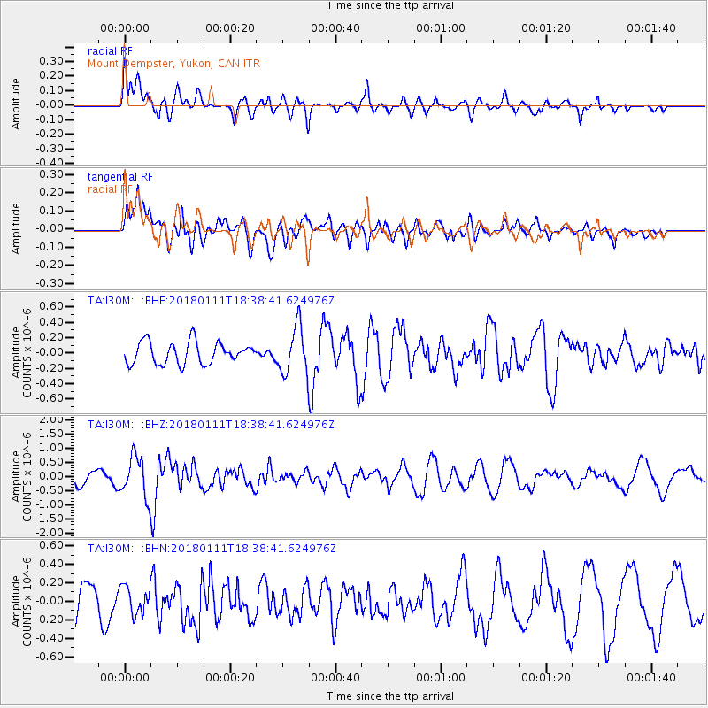
Signal To Noise
| Channel | StoN | STA | LTA |
| TA:I30M: :BHZ:20180111T18:38:41.624976Z | 3.2449732 | 7.2263305E-7 | 2.2269307E-7 |
| TA:I30M: :BHN:20180111T18:38:41.624976Z | 0.84699667 | 1.4579959E-7 | 1.7213715E-7 |
| TA:I30M: :BHE:20180111T18:38:41.624976Z | 2.2008834 | 3.1154534E-7 | 1.4155468E-7 |
| Arrivals |
| Ps | |
| PpPs | |
| PsPs/PpSs | |


