You are here: Home > Network List > TA - USArray Transportable Network (new EarthScope stations) Stations List
> Station J20K Nowitna River, AK, USA > Earthquake Result Viewer
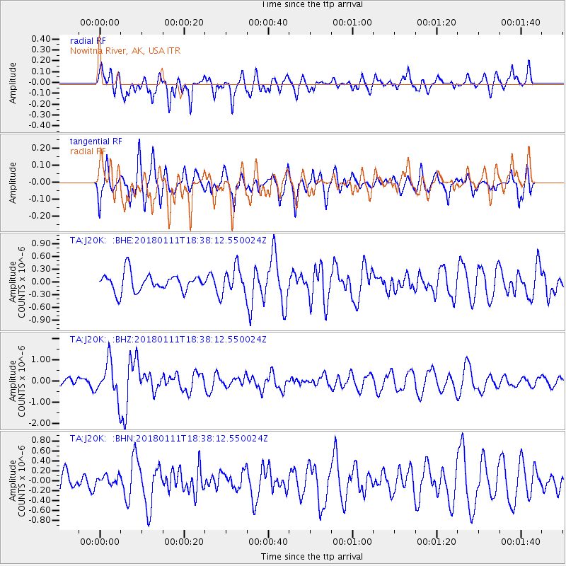
J20K Nowitna River, AK, USA - Earthquake Result Viewer
*The percent match for this event was below the threshold and hence no stack was calculated.
| Earthquake location: |
Myanmar |
| Earthquake latitude/longitude: |
18.4/96.1 |
| Earthquake time(UTC): |
2018/01/11 (011) 18:26:24 GMT |
| Earthquake Depth: |
10 km |
| Earthquake Magnitude: |
6.0 Mww |
| Earthquake Catalog/Contributor: |
NEIC PDE/us |
|
| Network: |
TA USArray Transportable Network (new EarthScope stations) |
| Station: |
J20K Nowitna River, AK, USA |
| Lat/Lon: |
64.18 N/154.15 W |
| Elevation: |
314 m |
|
| Distance: |
81.9 deg |
| Az: |
24.601 deg |
| Baz: |
295.485 deg |
| Ray Param: |
$rayparam |
*The percent match for this event was below the threshold and hence was not used in the summary stack. |
|
| Radial Match: |
74.20914 % |
| Radial Bump: |
400 |
| Transverse Match: |
55.74669 % |
| Transverse Bump: |
400 |
| SOD ConfigId: |
13570011 |
| Insert Time: |
2019-04-29 13:26:33.134 +0000 |
| GWidth: |
2.5 |
| Max Bumps: |
400 |
| Tol: |
0.001 |
|
Signal To Noise
| Channel | StoN | STA | LTA |
| TA:J20K: :BHZ:20180111T18:38:12.550024Z | 3.9353273 | 8.721377E-7 | 2.216176E-7 |
| TA:J20K: :BHN:20180111T18:38:12.550024Z | 0.35802805 | 9.156598E-8 | 2.5575085E-7 |
| TA:J20K: :BHE:20180111T18:38:12.550024Z | 1.4233538 | 2.997775E-7 | 2.1061348E-7 |
| Arrivals |
| Ps | |
| PpPs | |
| PsPs/PpSs | |


