You are here: Home > Network List > TJ - Tajikistan National Seismic Network Stations List
> Station CHGR Chuyangaron, Tajikistan > Earthquake Result Viewer
CHGR Chuyangaron, Tajikistan - Earthquake Result Viewer
| Earthquake location: |
Myanmar |
| Earthquake latitude/longitude: |
18.4/96.1 |
| Earthquake time(UTC): |
2018/01/11 (011) 18:26:24 GMT |
| Earthquake Depth: |
10 km |
| Earthquake Magnitude: |
6.0 Mww |
| Earthquake Catalog/Contributor: |
NEIC PDE/us |
|
| Network: |
TJ Tajikistan National Seismic Network |
| Station: |
CHGR Chuyangaron, Tajikistan |
| Lat/Lon: |
38.66 N/69.16 E |
| Elevation: |
1049 m |
|
| Distance: |
30.9 deg |
| Az: |
316.397 deg |
| Baz: |
123.222 deg |
| Ray Param: |
0.079202496 |
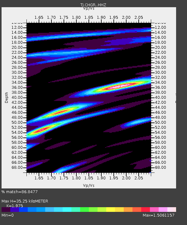
| Estimated Moho Depth: |
35.25 km |
| Estimated Crust Vp/Vs: |
1.98 |
| Assumed Crust Vp: |
6.483 km/s |
| Estimated Crust Vs: |
3.282 km/s |
| Estimated Crust Poisson's Ratio: |
0.33 |
|
| Radial Match: |
86.8477 % |
| Radial Bump: |
357 |
| Transverse Match: |
64.748344 % |
| Transverse Bump: |
400 |
| SOD ConfigId: |
13570011 |
| Insert Time: |
2019-04-29 13:27:07.989 +0000 |
| GWidth: |
2.5 |
| Max Bumps: |
400 |
| Tol: |
0.001 |
|

Signal To Noise
| Channel | StoN | STA | LTA |
| TJ:CHGR: :HHZ:20180111T18:32:10.630011Z | 16.002678 | 3.1042916E-6 | 1.9398574E-7 |
| TJ:CHGR: :HHN:20180111T18:32:10.630011Z | 7.562087 | 8.431948E-7 | 1.1150292E-7 |
| TJ:CHGR: :HHE:20180111T18:32:10.630011Z | 20.997791 | 1.4355468E-6 | 6.836657E-8 |
| Arrivals |
| Ps | 5.7 SECOND |
| PpPs | 15 SECOND |
| PsPs/PpSs | 21 SECOND |


