You are here: Home > Network List > G - GEOSCOPE Stations List
> Station TAOE Taiohae, Marquises islands > Earthquake Result Viewer
TAOE Taiohae, Marquises islands - Earthquake Result Viewer
| Earthquake location: |
Near Coast Of Ecuador |
| Earthquake latitude/longitude: |
0.4/-79.9 |
| Earthquake time(UTC): |
2016/04/16 (107) 23:58:37 GMT |
| Earthquake Depth: |
19 km |
| Earthquake Magnitude: |
7.8 MWW, 7.4 MI |
| Earthquake Catalog/Contributor: |
NEIC PDE/NEIC COMCAT |
|
| Network: |
G GEOSCOPE |
| Station: |
TAOE Taiohae, Marquises islands |
| Lat/Lon: |
8.85 S/140.15 W |
| Elevation: |
800 m |
|
| Distance: |
60.7 deg |
| Az: |
259.685 deg |
| Baz: |
84.58 deg |
| Ray Param: |
0.06136573 |
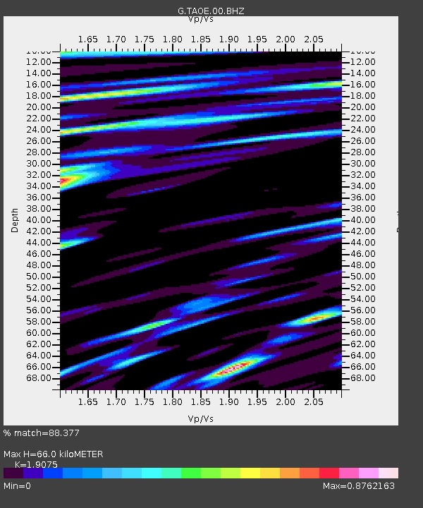
| Estimated Moho Depth: |
66.0 km |
| Estimated Crust Vp/Vs: |
1.91 |
| Assumed Crust Vp: |
4.24 km/s |
| Estimated Crust Vs: |
2.223 km/s |
| Estimated Crust Poisson's Ratio: |
0.31 |
|
| Radial Match: |
88.377 % |
| Radial Bump: |
400 |
| Transverse Match: |
78.42629 % |
| Transverse Bump: |
400 |
| SOD ConfigId: |
1475611 |
| Insert Time: |
2016-05-01 00:02:42.624 +0000 |
| GWidth: |
2.5 |
| Max Bumps: |
400 |
| Tol: |
0.001 |
|
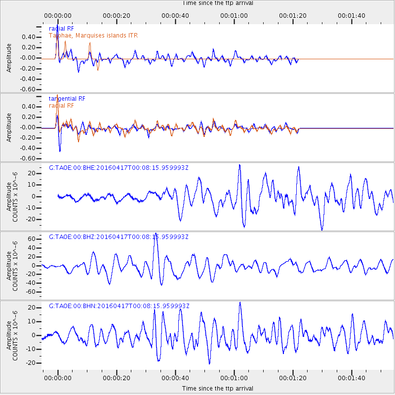
Signal To Noise
| Channel | StoN | STA | LTA |
| G:TAOE:00:BHZ:20160417T00:08:15.959993Z | 2.79005 | 8.600309E-6 | 3.0824929E-6 |
| G:TAOE:00:BHN:20160417T00:08:15.959993Z | 1.516132 | 3.520524E-6 | 2.3220432E-6 |
| G:TAOE:00:BHE:20160417T00:08:15.959993Z | 1.5825129 | 3.3448707E-6 | 2.1136452E-6 |
| Arrivals |
| Ps | 14 SECOND |
| PpPs | 44 SECOND |
| PsPs/PpSs | 59 SECOND |


