You are here: Home > Network List > GS - US Geological Survey Networks Stations List
> Station DEC05 Decatur Surface Seismic Site, Decatur, IL, USA > Earthquake Result Viewer
DEC05 Decatur Surface Seismic Site, Decatur, IL, USA - Earthquake Result Viewer

| Earthquake location: |
Near Coast Of Ecuador |
| Earthquake latitude/longitude: |
0.4/-79.9 |
| Earthquake time(UTC): |
2016/04/16 (107) 23:58:37 GMT |
| Earthquake Depth: |
19 km |
| Earthquake Magnitude: |
7.8 MWW, 7.4 MI |
| Earthquake Catalog/Contributor: |
NEIC PDE/NEIC COMCAT |
|
| Network: |
GS US Geological Survey Networks |
| Station: |
DEC05 Decatur Surface Seismic Site, Decatur, IL, USA |
| Lat/Lon: |
39.87 N/88.87 W |
| Elevation: |
216 m |
|
| Distance: |
40.1 deg |
| Az: |
349.326 deg |
| Baz: |
166.075 deg |
| Ray Param: |
0.07453692 |
| Estimated Moho Depth: |
23.5 km |
| Estimated Crust Vp/Vs: |
1.84 |
| Assumed Crust Vp: |
6.444 km/s |
| Estimated Crust Vs: |
3.502 km/s |
| Estimated Crust Poisson's Ratio: |
0.29 |
|
| Radial Match: |
94.4788 % |
| Radial Bump: |
281 |
| Transverse Match: |
83.21984 % |
| Transverse Bump: |
400 |
| SOD ConfigId: |
1475611 |
| Insert Time: |
2016-05-01 00:02:55.094 +0000 |
| GWidth: |
2.5 |
| Max Bumps: |
400 |
| Tol: |
0.001 |
|
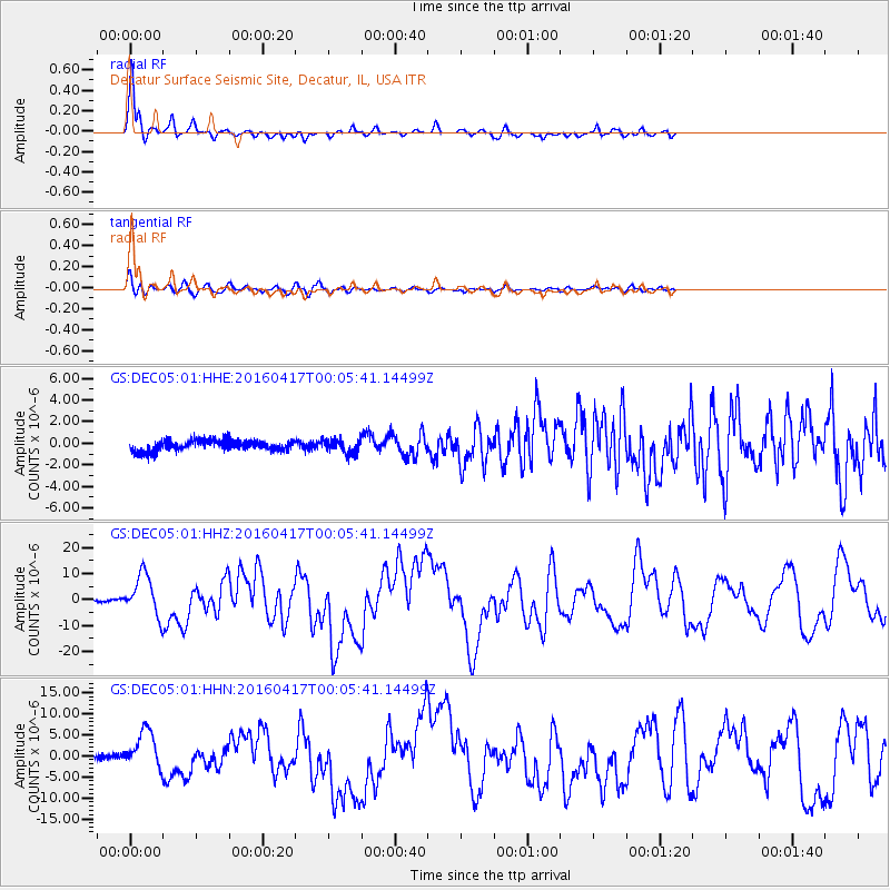
Signal To Noise
| Channel | StoN | STA | LTA |
| GS:DEC05:01:HHZ:20160417T00:05:41.14499Z | 27.396221 | 7.787702E-6 | 2.8426192E-7 |
| GS:DEC05:01:HHN:20160417T00:05:41.14499Z | 7.4984746 | 4.4556427E-6 | 5.942066E-7 |
| GS:DEC05:01:HHE:20160417T00:05:41.14499Z | 1.3280615 | 6.621797E-7 | 4.986062E-7 |
| Arrivals |
| Ps | 3.3 SECOND |
| PpPs | 9.7 SECOND |
| PsPs/PpSs | 13 SECOND |


