You are here: Home > Network List > GS - US Geological Survey Networks Stations List
> Station DEC07 Decatur Surface Seismic Site, Decatur, IL, USA > Earthquake Result Viewer
DEC07 Decatur Surface Seismic Site, Decatur, IL, USA - Earthquake Result Viewer

| Earthquake location: |
Near Coast Of Ecuador |
| Earthquake latitude/longitude: |
0.4/-79.9 |
| Earthquake time(UTC): |
2016/04/16 (107) 23:58:37 GMT |
| Earthquake Depth: |
19 km |
| Earthquake Magnitude: |
7.8 MWW, 7.4 MI |
| Earthquake Catalog/Contributor: |
NEIC PDE/NEIC COMCAT |
|
| Network: |
GS US Geological Survey Networks |
| Station: |
DEC07 Decatur Surface Seismic Site, Decatur, IL, USA |
| Lat/Lon: |
39.86 N/88.90 W |
| Elevation: |
212 m |
|
| Distance: |
40.1 deg |
| Az: |
349.286 deg |
| Baz: |
166.023 deg |
| Ray Param: |
0.07453632 |
| Estimated Moho Depth: |
23.0 km |
| Estimated Crust Vp/Vs: |
1.87 |
| Assumed Crust Vp: |
6.444 km/s |
| Estimated Crust Vs: |
3.455 km/s |
| Estimated Crust Poisson's Ratio: |
0.30 |
|
| Radial Match: |
95.1237 % |
| Radial Bump: |
282 |
| Transverse Match: |
80.2057 % |
| Transverse Bump: |
400 |
| SOD ConfigId: |
1475611 |
| Insert Time: |
2016-05-01 00:03:07.274 +0000 |
| GWidth: |
2.5 |
| Max Bumps: |
400 |
| Tol: |
0.001 |
|
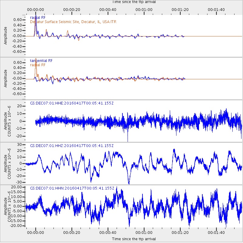
Signal To Noise
| Channel | StoN | STA | LTA |
| GS:DEC07:01:HHZ:20160417T00:05:41.155Z | 9.546121 | 7.674247E-6 | 8.039127E-7 |
| GS:DEC07:01:HHN:20160417T00:05:41.155Z | 1.9367667 | 4.5029965E-6 | 2.3250072E-6 |
| GS:DEC07:01:HHE:20160417T00:05:41.155Z | 1.3433086 | 4.209518E-6 | 3.1336938E-6 |
| Arrivals |
| Ps | 3.3 SECOND |
| PpPs | 9.6 SECOND |
| PsPs/PpSs | 13 SECOND |


