You are here: Home > Network List > TA - USArray Transportable Network (new EarthScope stations) Stations List
> Station J26L Joseph Creek, AK, USA > Earthquake Result Viewer
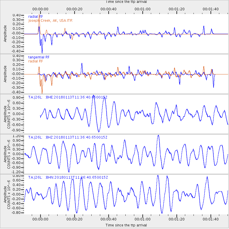
J26L Joseph Creek, AK, USA - Earthquake Result Viewer
*The percent match for this event was below the threshold and hence no stack was calculated.
| Earthquake location: |
Solomon Islands |
| Earthquake latitude/longitude: |
-11.2/163.0 |
| Earthquake time(UTC): |
2018/01/13 (013) 11:24:37 GMT |
| Earthquake Depth: |
24 km |
| Earthquake Magnitude: |
5.9 Mww |
| Earthquake Catalog/Contributor: |
NEIC PDE/us |
|
| Network: |
TA USArray Transportable Network (new EarthScope stations) |
| Station: |
J26L Joseph Creek, AK, USA |
| Lat/Lon: |
64.50 N/143.56 W |
| Elevation: |
1144 m |
|
| Distance: |
85.5 deg |
| Az: |
20.406 deg |
| Baz: |
232.222 deg |
| Ray Param: |
$rayparam |
*The percent match for this event was below the threshold and hence was not used in the summary stack. |
|
| Radial Match: |
67.89965 % |
| Radial Bump: |
334 |
| Transverse Match: |
33.691208 % |
| Transverse Bump: |
299 |
| SOD ConfigId: |
13570011 |
| Insert Time: |
2019-04-29 13:31:12.262 +0000 |
| GWidth: |
2.5 |
| Max Bumps: |
400 |
| Tol: |
0.001 |
|
Signal To Noise
| Channel | StoN | STA | LTA |
| TA:J26L: :BHZ:20180113T11:36:40.650015Z | 1.2501782 | 3.7067565E-7 | 2.9649826E-7 |
| TA:J26L: :BHN:20180113T11:36:40.650015Z | 0.35374835 | 1.143606E-7 | 3.2328234E-7 |
| TA:J26L: :BHE:20180113T11:36:40.650015Z | 3.608884 | 7.111535E-7 | 1.9705635E-7 |
| Arrivals |
| Ps | |
| PpPs | |
| PsPs/PpSs | |


