You are here: Home > Network List > 5H - Central Virginia and South Carolina seismic monitoring experiment Stations List
> Station BEAR Cumberland S.F., VA > Earthquake Result Viewer
BEAR Cumberland S.F., VA - Earthquake Result Viewer
| Earthquake location: |
Near Coast Of Peru |
| Earthquake latitude/longitude: |
-15.8/-74.7 |
| Earthquake time(UTC): |
2018/01/14 (014) 09:18:45 GMT |
| Earthquake Depth: |
36 km |
| Earthquake Magnitude: |
7.1 mww |
| Earthquake Catalog/Contributor: |
NEIC PDE/us |
|
| Network: |
5H Central Virginia and South Carolina seismic monitoring experiment |
| Station: |
BEAR Cumberland S.F., VA |
| Lat/Lon: |
37.53 N/78.29 W |
| Elevation: |
107 m |
|
| Distance: |
53.1 deg |
| Az: |
356.479 deg |
| Baz: |
175.734 deg |
| Ray Param: |
0.0662373 |
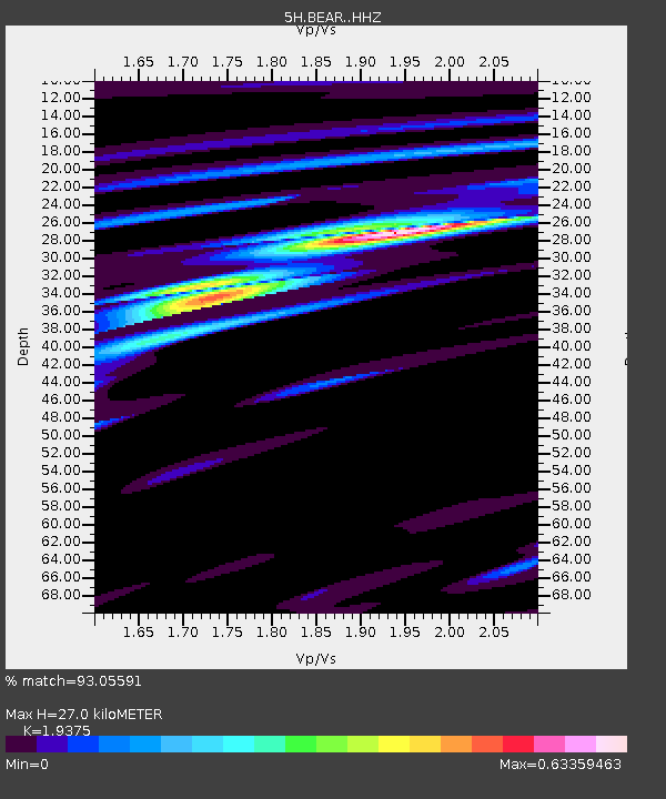
| Estimated Moho Depth: |
27.0 km |
| Estimated Crust Vp/Vs: |
1.94 |
| Assumed Crust Vp: |
6.419 km/s |
| Estimated Crust Vs: |
3.313 km/s |
| Estimated Crust Poisson's Ratio: |
0.32 |
|
| Radial Match: |
93.05591 % |
| Radial Bump: |
400 |
| Transverse Match: |
73.31107 % |
| Transverse Bump: |
400 |
| SOD ConfigId: |
13570011 |
| Insert Time: |
2019-04-29 13:32:44.933 +0000 |
| GWidth: |
2.5 |
| Max Bumps: |
400 |
| Tol: |
0.001 |
|

Signal To Noise
| Channel | StoN | STA | LTA |
| 5H:BEAR: :HHZ:20180114T09:27:28.59002Z | 24.097347 | 1.36501985E-5 | 5.6646064E-7 |
| 5H:BEAR: :HHN:20180114T09:27:28.59002Z | 10.515151 | 7.200578E-6 | 6.847812E-7 |
| 5H:BEAR: :HHE:20180114T09:27:28.59002Z | 4.4581966 | 2.513459E-6 | 5.6378383E-7 |
| Arrivals |
| Ps | 4.1 SECOND |
| PpPs | 12 SECOND |
| PsPs/PpSs | 16 SECOND |


