You are here: Home > Network List > 5H - Central Virginia and South Carolina seismic monitoring experiment Stations List
> Station GOOD Gooden Farm > Earthquake Result Viewer
GOOD Gooden Farm - Earthquake Result Viewer
| Earthquake location: |
Near Coast Of Peru |
| Earthquake latitude/longitude: |
-15.8/-74.7 |
| Earthquake time(UTC): |
2018/01/14 (014) 09:18:45 GMT |
| Earthquake Depth: |
36 km |
| Earthquake Magnitude: |
7.1 mww |
| Earthquake Catalog/Contributor: |
NEIC PDE/us |
|
| Network: |
5H Central Virginia and South Carolina seismic monitoring experiment |
| Station: |
GOOD Gooden Farm |
| Lat/Lon: |
37.60 N/78.64 W |
| Elevation: |
175 m |
|
| Distance: |
53.2 deg |
| Az: |
356.132 deg |
| Baz: |
175.309 deg |
| Ray Param: |
0.06617299 |
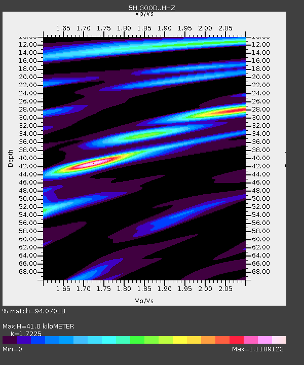
| Estimated Moho Depth: |
41.0 km |
| Estimated Crust Vp/Vs: |
1.72 |
| Assumed Crust Vp: |
6.419 km/s |
| Estimated Crust Vs: |
3.727 km/s |
| Estimated Crust Poisson's Ratio: |
0.25 |
|
| Radial Match: |
94.07018 % |
| Radial Bump: |
344 |
| Transverse Match: |
82.588234 % |
| Transverse Bump: |
400 |
| SOD ConfigId: |
13570011 |
| Insert Time: |
2019-04-29 13:33:01.611 +0000 |
| GWidth: |
2.5 |
| Max Bumps: |
400 |
| Tol: |
0.001 |
|

Signal To Noise
| Channel | StoN | STA | LTA |
| 5H:GOOD: :HHZ:20180114T09:27:29.29998Z | 17.82897 | 1.4600785E-5 | 8.18936E-7 |
| 5H:GOOD: :HHN:20180114T09:27:29.29998Z | 18.316751 | 8.255647E-6 | 4.5071567E-7 |
| 5H:GOOD: :HHE:20180114T09:27:29.29998Z | 3.211002 | 2.1652063E-6 | 6.7430864E-7 |
| Arrivals |
| Ps | 4.9 SECOND |
| PpPs | 16 SECOND |
| PsPs/PpSs | 21 SECOND |


