You are here: Home > Network List > AK - Alaska Regional Network Stations List
> Station CUT Chulitna, AK, USA > Earthquake Result Viewer
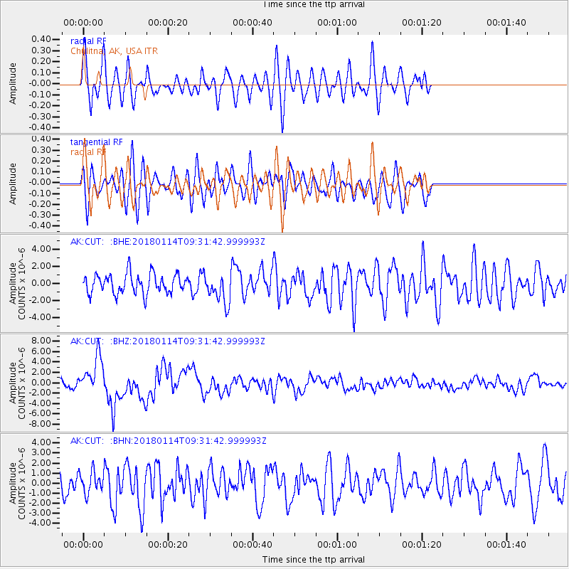
CUT Chulitna, AK, USA - Earthquake Result Viewer
*The percent match for this event was below the threshold and hence no stack was calculated.
| Earthquake location: |
Near Coast Of Peru |
| Earthquake latitude/longitude: |
-15.8/-74.7 |
| Earthquake time(UTC): |
2018/01/14 (014) 09:18:45 GMT |
| Earthquake Depth: |
36 km |
| Earthquake Magnitude: |
7.1 mww |
| Earthquake Catalog/Contributor: |
NEIC PDE/us |
|
| Network: |
AK Alaska Regional Network |
| Station: |
CUT Chulitna, AK, USA |
| Lat/Lon: |
62.41 N/150.26 W |
| Elevation: |
574 m |
|
| Distance: |
97.3 deg |
| Az: |
332.965 deg |
| Baz: |
109.978 deg |
| Ray Param: |
$rayparam |
*The percent match for this event was below the threshold and hence was not used in the summary stack. |
|
| Radial Match: |
65.87887 % |
| Radial Bump: |
400 |
| Transverse Match: |
40.16608 % |
| Transverse Bump: |
400 |
| SOD ConfigId: |
13570011 |
| Insert Time: |
2019-04-29 13:33:38.276 +0000 |
| GWidth: |
2.5 |
| Max Bumps: |
400 |
| Tol: |
0.001 |
|
Signal To Noise
| Channel | StoN | STA | LTA |
| AK:CUT: :BHZ:20180114T09:31:42.999993Z | 4.704189 | 3.7085051E-6 | 7.88341E-7 |
| AK:CUT: :BHN:20180114T09:31:42.999993Z | 0.6504781 | 1.0684043E-6 | 1.6424908E-6 |
| AK:CUT: :BHE:20180114T09:31:42.999993Z | 1.5828997 | 1.7925739E-6 | 1.1324621E-6 |
| Arrivals |
| Ps | |
| PpPs | |
| PsPs/PpSs | |


