You are here: Home > Network List > GS - US Geological Survey Networks Stations List
> Station KAN05 Marsh Home, Bluff City, KS, USA > Earthquake Result Viewer
KAN05 Marsh Home, Bluff City, KS, USA - Earthquake Result Viewer
| Earthquake location: |
Near Coast Of Ecuador |
| Earthquake latitude/longitude: |
0.4/-79.9 |
| Earthquake time(UTC): |
2016/04/16 (107) 23:58:37 GMT |
| Earthquake Depth: |
19 km |
| Earthquake Magnitude: |
7.8 MWW, 7.4 MI |
| Earthquake Catalog/Contributor: |
NEIC PDE/NEIC COMCAT |
|
| Network: |
GS US Geological Survey Networks |
| Station: |
KAN05 Marsh Home, Bluff City, KS, USA |
| Lat/Lon: |
37.11 N/97.87 W |
| Elevation: |
348 m |
|
| Distance: |
40.1 deg |
| Az: |
337.554 deg |
| Baz: |
151.472 deg |
| Ray Param: |
0.07454001 |
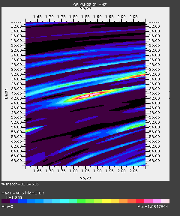
| Estimated Moho Depth: |
40.5 km |
| Estimated Crust Vp/Vs: |
1.87 |
| Assumed Crust Vp: |
6.483 km/s |
| Estimated Crust Vs: |
3.476 km/s |
| Estimated Crust Poisson's Ratio: |
0.30 |
|
| Radial Match: |
81.64536 % |
| Radial Bump: |
400 |
| Transverse Match: |
40.71444 % |
| Transverse Bump: |
400 |
| SOD ConfigId: |
1475611 |
| Insert Time: |
2016-05-01 00:03:44.334 +0000 |
| GWidth: |
2.5 |
| Max Bumps: |
400 |
| Tol: |
0.001 |
|
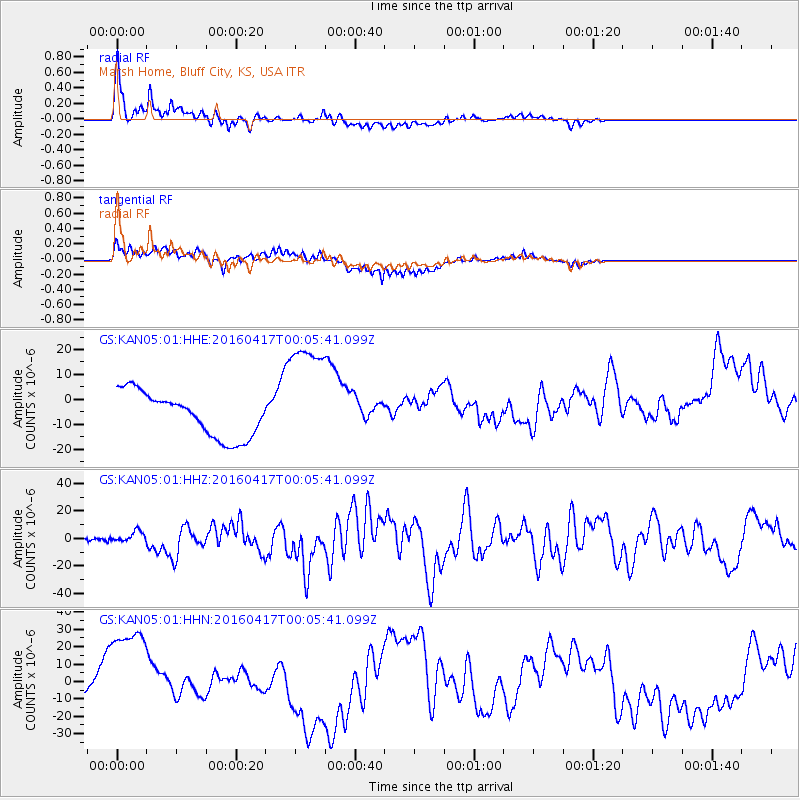
Signal To Noise
| Channel | StoN | STA | LTA |
| GS:KAN05:01:HHZ:20160417T00:05:41.099Z | 6.3458056 | 4.192516E-6 | 6.6067514E-7 |
| GS:KAN05:01:HHN:20160417T00:05:41.099Z | 3.9963238 | 3.181183E-5 | 7.960273E-6 |
| GS:KAN05:01:HHE:20160417T00:05:41.099Z | 2.7595272 | 2.4354054E-5 | 8.825445E-6 |
| Arrivals |
| Ps | 5.8 SECOND |
| PpPs | 17 SECOND |
| PsPs/PpSs | 23 SECOND |


