You are here: Home > Network List > C - Chilean National Seismic Network Stations List
> Station GO09 Cerro Castillo, Chile > Earthquake Result Viewer
GO09 Cerro Castillo, Chile - Earthquake Result Viewer
| Earthquake location: |
Near Coast Of Peru |
| Earthquake latitude/longitude: |
-15.8/-74.7 |
| Earthquake time(UTC): |
2018/01/14 (014) 09:18:45 GMT |
| Earthquake Depth: |
36 km |
| Earthquake Magnitude: |
7.1 mww |
| Earthquake Catalog/Contributor: |
NEIC PDE/us |
|
| Network: |
C Chilean National Seismic Network |
| Station: |
GO09 Cerro Castillo, Chile |
| Lat/Lon: |
51.27 S/72.34 W |
| Elevation: |
372 m |
|
| Distance: |
35.5 deg |
| Az: |
177.395 deg |
| Baz: |
356.005 deg |
| Ray Param: |
0.07713983 |
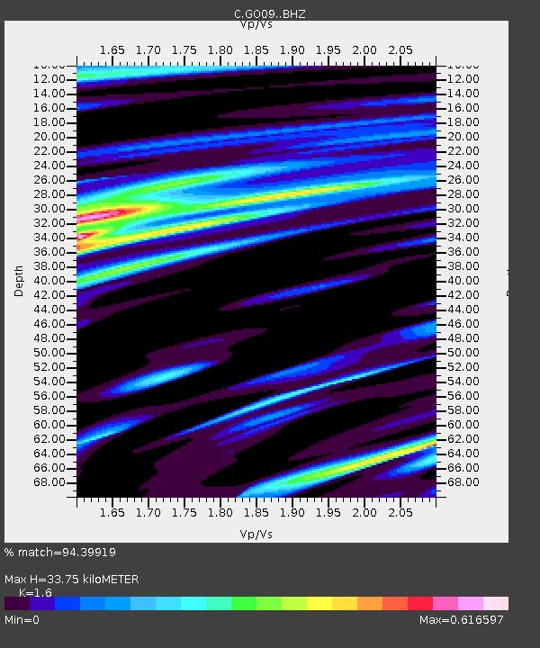
| Estimated Moho Depth: |
33.75 km |
| Estimated Crust Vp/Vs: |
1.60 |
| Assumed Crust Vp: |
6.438 km/s |
| Estimated Crust Vs: |
4.024 km/s |
| Estimated Crust Poisson's Ratio: |
0.18 |
|
| Radial Match: |
94.39919 % |
| Radial Bump: |
400 |
| Transverse Match: |
82.17004 % |
| Transverse Bump: |
400 |
| SOD ConfigId: |
13570011 |
| Insert Time: |
2019-04-29 13:34:57.105 +0000 |
| GWidth: |
2.5 |
| Max Bumps: |
400 |
| Tol: |
0.001 |
|

Signal To Noise
| Channel | StoN | STA | LTA |
| C:GO09: :BHZ:20180114T09:25:07.974999Z | 12.627674 | 1.2446188E-5 | 9.856279E-7 |
| C:GO09: :BHN:20180114T09:25:07.974999Z | 9.383555 | 6.6672246E-6 | 7.105222E-7 |
| C:GO09: :BHE:20180114T09:25:07.974999Z | 1.5824091 | 1.2376981E-6 | 7.821606E-7 |
| Arrivals |
| Ps | 3.4 SECOND |
| PpPs | 13 SECOND |
| PsPs/PpSs | 16 SECOND |


